Yakima (Washington)
Yakima (bis 1918 North Yakima) ist eine Stadt in Zentral-Washington und Sitz des Yakima Countys.
| Yakima | |
|---|---|
| Spitzname: The Palm Springs of Washington | |
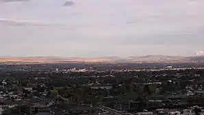 Ansicht | |
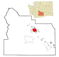
| Lage im County und im Bundesstaat | |
 | |
| Basisdaten | |
| Gründung: | 1883 |
| Staat: | Vereinigte Staaten |
| Bundesstaat: | Washington |
| County: | Yakima County |
| Koordinaten: | 46° 36′ N, 120° 32′ W |
| Zeitzone: | Pacific (UTC−8/−7) |
| Einwohner: – Metropolregion: | 96.968 (Stand: 2020) 249.636 (Stand: 2016) |
| Fläche: | 53,4 km² (ca. 21 mi²) davon 52,1 km² (ca. 20 mi²) Land |
| Höhe: | 325 m |
| Postleitzahlen: | 98901–98904, 98907–98909 |
| Vorwahl: | +1 509 |
| FIPS: | 53-80010 |
| GNIS-ID: | 1509643 |
| Website: | www.ci.yakima.wa.us |
| Bürgermeister: | Dave Edler |
Sie hat 96.968[1] Einwohner (Stand 2020) und befindet sich im Yakima Valley. Der Name stammt vom indigenen Volk der Yakima, noch heute befindet sich das Indianerreservat Yakama Indian Reservation im Süden/Südwesten von Yakima.
Die Stadt hat eine Fläche von 53,4 km². Bedeutende Wirtschaftszweige sind der Obstanbau, insbesondere der Anbau von Wein (siehe Yakima Valley AVA).
Das Militär unterhält Truppenübungsplätze und Munitionslager in der Gegend.[2] Die NSA betreibt die Yakima Research Station.[3] Die Public Radio Station KDNA sendet ein spanischsprachiges Programm für die Hispanic Community in Yakima.
An der South 48th Avenue kaufte Belinda Mulrooney 1909 ein 22 Acres großes Grundstück, auf dem sie ein großes Steinhaus baute, das Carbonneau Castle.
Einwohnerentwicklung
| Jahr | Einwohner¹ |
|---|---|
| 1980 | 49.826 |
| 1990 | 58.427 |
| 2000 | 80.056 |
| 2010 | 91.067[4] |
| 2016 | 93.986 |
| 2020 | 96.968 |
¹ 1980–2020: Volkszählungsergebnisse; 2016: Fortschreibung des US Census Bureau
Verkehr
- U.S. Highway 12
- Yakima Air Terminal (McAllister Field; IATA: YKM, ICAO: KYKM, FAA LID: YKM)
Klimatabelle
| Yakima, Washington | ||||||||||||||||||||||||||||||||||||||||||||||||
|---|---|---|---|---|---|---|---|---|---|---|---|---|---|---|---|---|---|---|---|---|---|---|---|---|---|---|---|---|---|---|---|---|---|---|---|---|---|---|---|---|---|---|---|---|---|---|---|---|
| Klimadiagramm | ||||||||||||||||||||||||||||||||||||||||||||||||
| ||||||||||||||||||||||||||||||||||||||||||||||||
|
Monatliche Durchschnittstemperaturen und -niederschläge für Yakima, Washington
| |||||||||||||||||||||||||||||||||||||||||||||||||||||||||||||||||||||||||||||||||||||||||||||||||||||||||
Söhne und Töchter der Stadt
- Ray Cory (1894–1968), Fotograf und Kameramann
- Barbara La Marr (1896–1926), Schauspielerin, Drehbuchautorin und Journalistin
- Paul Cannon (1897–1986), Politiker
- Catherine Dean May (1914–2004), Politiker
- Claire Austin (1918–1994), Blues- und Jazzsängerin
- Robert Middlekauff (1929–2021), Historiker und Professor
- Jim Rohn (1930–2009), Unternehmer, Autor und Motivationstrainer
- Colleen Miller (* 1932), Schauspielerin
- Sid Morrison (* 1933), Politiker
- Llyn Foulkes (* 1934), Künstler
- Robert E. Lucas (* 1937), Ökonom und Nobelpreisträger
- Colleen Atwood (* 1948), Kostümbildnerin
- Stephen McAlpine (* 1949), Politiker
- Larry McLerran (* 1949), Kernphysiker
- Sam Kinison (1953–1992), Komiker und Schauspieler
- Dan Doornink (* 1956), American-Football-Spieler
- Phil Mahre (* 1957), Skirennläufer
- Steve Mahre (* 1957), Skirennläufer
- Kyle MacLachlan (* 1959), Schauspieler
- Christopher Wiehl (* 1970), Schauspieler
- Cooper Kupp (* 1993), American-Football-Spieler
Weblinks
- Eintrag in der Washington-Enzyklopädie HistoryLink (englisch)
- Everything Yakima – events, businesses, and community information site (englisch)
- Yakima Visitor & Convention Bureau (englisch)
- Winzer in Yakima (Memento vom 28. August 2008 im Internet Archive) (englisch)
Einzelnachweise
- U.S. Census Bureau QuickFacts: Yakima city, Washington. Abgerufen am 27. Februar 2022 (englisch).
- http://www.thelivingmoon.com/45jack_files/03files/ECHELON_Yakima.html
- http://world-information.org/wio/infostructure/100437611746/100438659207/?ic=100446325802
- 2010 Demographic Profile