Sántos
Sántos ist eine ungarische Gemeinde im Kreis Kaposvár im Komitat Somogy.
| Sántos | |||||
| |||||
| Basisdaten | |||||
|---|---|---|---|---|---|
| Staat: | Ungarn | ||||
| Region: | Südtransdanubien | ||||
| Komitat: | Somogy | ||||
| Kleingebiet bis 31.12.2012: | Kaposvár | ||||
| Kreis seit 1.1.2013: | Kaposvár | ||||
| Koordinaten: | 46° 21′ N, 17° 53′ O | ||||
| Fläche: | 11,38 km² | ||||
| Einwohner: | 521 (1. Jan. 2011) | ||||
| Bevölkerungsdichte: | 46 Einwohner je km² | ||||
| Telefonvorwahl: | (+36) 82 | ||||
| Postleitzahl: | 7479 | ||||
| KSH-kód: | 31121 | ||||
| Struktur und Verwaltung (Stand: 2018) | |||||
| Gemeindeart: | Gemeinde | ||||
| Bürgermeisterin: | Mária Margit Antalné Keresztes (parteilos) | ||||
| Postanschrift: | Fő utca 112 7479 Sántos | ||||
| Website: | |||||
| (Quelle: A Magyar Köztársaság helységnévkönyve 2011. január 1. bei Központi statisztikai hivatal) | |||||


Geografische Lage
Sántos liegt siebeneinhalb Kilometer östlich der Stadt Kaposvár. Nachbargemeinden sind Szentbalázs, Taszár und Cserénfa.
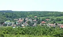
Blick auf Sántos
Sehenswürdigkeiten
- Römisch-katholische Kirche Szent Vendel
Verkehr
Durch Sántos verläuft die Hauptstraße Nr. 66. Der nächstgelegene Bahnhof befindet sich gut zwei Kilometer nordöstlich in Taszár.
Weblinks
- Offizielle Webseite (ungarisch)
- Sántos község címere (ungarisch)
This article is issued from Wikipedia. The text is licensed under Creative Commons - Attribution - Sharealike. The authors of the article are listed here. Additional terms may apply for the media files, click on images to show image meta data.