Parry Sound District
Der Parry Sound District ist ein Verwaltungsbezirk im Zentrum der kanadischen Provinz Ontario. Hauptort ist Parry Sound. Die Einwohnerzahl beträgt 42.824 (Stand: 2016), die Fläche 9326,48 km², was einer Bevölkerungsdichte von 4,6 Einwohnern je km² entspricht. Der Bezirk liegt am Ostufer der Georgsbucht des Huronsees und umfasst einen Teil des Biosphärenreservat Frontenac Arch.
| Sudbury District | Nipissing District | |
| Georgian Bay (Huronsee) | .svg.png.webp) |
Nipissing District |
| Muskoka District Municipality |
| Parry Sound District | |
|---|---|
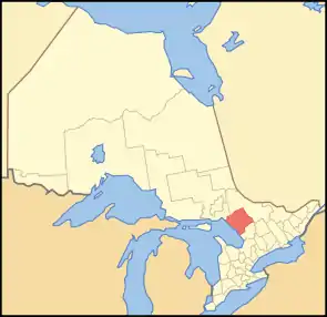 Lage der Region in Ontario | |
| Basisdaten | |
| Staat | Kanada |
| Provinz | Ontario |
| Verwaltungssitz | Parry Sound |
| Koordinaten: | 45° 43′ N, 79° 48′ W |
| Einwohner | 42.824 (Stand: 2016[1]) |
| Fläche | 9.326,48 km² |
| Bevölkerungsdichte | 4,6 Einw./km² |
| Zeitzone: | Eastern Standard Time (UTC−5) Eastern Daylight Time (UTC−4, Sommerzeit) |
Administrative Gliederung
Städte und Gemeinden
| Ort | Status[2] | Bevölkerung (2016)[3] |
|---|---|---|
| Armour | Township | 1.414 |
| Burk's Falls | Village | 981 |
| Callander | Township | 3.863 |
| Carling | Township | 1.125 |
| Joly | Township | 304 |
| Kearney | Town | 882 |
| Machar | Township | 882 |
| Magnetawan | Township | 1.390 |
| McDougall | Township | 2.702 |
| McKellar | Township | 1.111 |
| McMurrich/Monteith | Township | 824 |
| Nipissing | Township | 1.707 |
| Parry Sound | Town | 6.408 |
| Perry | Township | 2.454 |
| Powassan | Town | 3.455 |
| Ryerson | Township | 648 |
| Seguin | Township | 4.304 |
| South River | Village | 1.114 |
| Strong | Township | 1.439 |
| Sundridge | Village | 961 |
| The Archipelago | Township | 531 |
| Whitestone | Township | 916 |
Gemeindefreie Gebiete
- Parry Sound, Unorganized, Centre Part
- Parry Sound, Unorganized, North East Part
Indianerreservationen
- Dokis 9
- French River 13
- Henvey Inlet 2
- Magnetawan 1
- Naiscoutaing 17A
- Parry Island First Nation
- Shawanaga 17
Weblinks
Einzelnachweise
- Statistics Canada: Census Profile, 2016 Census – Parry Sound, District (Census division), Ontario and Ontario (Province), abgerufen am 27. Mai 2021
- List of municipalities. Ontario Ministry of Municipal Affairs and Housing, 11. Mai 2021, abgerufen am 17. September 2021 (englisch).
- Census Profile, 2016 Census - Provincial Data. 17. Juni 2019, abgerufen am 17. September 2021 (englisch).
Einstufige Gemeinden: Brant | Brantford | Chatham-Kent | Greater Sudbury | Haldimand | Hamilton | Kawartha Lakes | Norfolk | Ottawa | Prince Edward | Toronto
Regionalgemeinden: Durham | Halton | Muskoka | Niagara | Oxford | Peel | Waterloo | York
Countys: Bruce | Dufferin | Elgin | Essex | Frontenac | Grey | Haliburton | Hastings | Huron | Lambton | Lanark | Leeds and Grenville | Lennox and Addington | Middlesex | Northumberland | Perth | Peterborough | Prescott and Russell | Renfrew | Simcoe | Stormont, Dundas and Glengarry | Wellington
Distrikte: Algoma | Cochrane | Kenora | Manitoulin | Nipissing | Parry Sound | Rainy River | Sudbury | Thunder Bay | Timiskaming