Oursbelille
| Oursbelille | ||
|---|---|---|
.svg.png.webp)
|
| |
| Staat | Frankreich | |
| Region | Okzitanien | |
| Département (Nr.) | Hautes-Pyrénées (65) | |
| Arrondissement | Tarbes | |
| Kanton | Bordères-sur-l’Échez | |
| Gemeindeverband | Tarbes-Lourdes-Pyrénées | |
| Koordinaten | 43° 17′ N, 0° 2′ O | |
| Höhe | 259–376 m | |
| Fläche | 11,46 km² | |
| Einwohner | 1.197 (1. Januar 2019) | |
| Bevölkerungsdichte | 104 Einw./km² | |
| Postleitzahl | 65490 | |
| INSEE-Code | 65350 | |
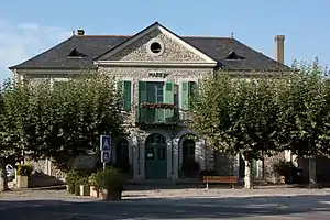 Mairie Oursbelille | ||

Oursbelille ist eine französische Gemeinde im Département Hautes-Pyrénées in der Region Okzitanien. Sie liegt im Arrondissement Tarbes und zum Kanton Bordères-sur-l’Échez.
Geographie
Oursbelille hat 1197 Einwohner (Stand 1. Januar 2019) auf 11,33 Quadratkilometern und liegt etwa 7 Kilometer nordnordwestlich von Tarbes in der Landschaft Bigorre am Échez und seinem Nebenfluss Souy.
Einwohnerentwicklung
- 1962: 689
- 1968: 843
- 1975: 984
- 1982: 1.105
- 1990: 1.213
- 1999: 1.198
- 2006: 1.200
- 2010: 1.219
Sehenswürdigkeiten
Neben der Kirche Invention-de-Saint-Étienne ist das heute privat genutzte Château de la Montjoie hervorzuheben.
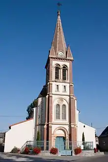
Kirche Invention-de-Saint-Étienne
Weblinks
Commons: Oursbelille – Sammlung von Bildern, Videos und Audiodateien
This article is issued from Wikipedia. The text is licensed under Creative Commons - Attribution - Sharealike. The authors of the article are listed here. Additional terms may apply for the media files, click on images to show image meta data.