Orthevielle
Orthevielle (okzitanisch Orta Vièla) ist eine französische Gemeinde mit 1.002 Einwohnern (Stand 1. Januar 2019) im Département Landes in der Region Nouvelle-Aquitaine (vor 2016 Aquitaine) im Südwesten Frankreichs. Sie gehört zum Arrondissement Dax und zum Kanton Orthe et Arrigans (bis 2015 Peyrehorade). Die Einwohner werden Ortheviellais genannt.
| Orthevielle Orta Vièla | ||
|---|---|---|
| ||
| Staat | Frankreich | |
| Region | Nouvelle-Aquitaine | |
| Département (Nr.) | Landes (40) | |
| Arrondissement | Dax | |
| Kanton | Orthe et Arrigans | |
| Gemeindeverband | Pays d’Orthe et Arrigans | |
| Koordinaten | 43° 33′ N, 1° 9′ W | |
| Höhe | 1–106 m | |
| Fläche | 14,01 km² | |
| Einwohner | 1.002 (1. Januar 2019) | |
| Bevölkerungsdichte | 72 Einw./km² | |
| Postleitzahl | 40300 | |
| INSEE-Code | 40212 | |
| Website | https://www.orthevielle.fr/ | |

Geografie
Orthevielle liegt am Fluss Gaves Réunis rund 25 Kilometer nordöstlich von Bayonne. Nachbargemeinden sind Saint-Lon-les-Mines im Norden und Nordwesten, Bélus im Norden und Nordosten, Peyrehorade im Osten, Hastingues im Süden sowie Port-de-Lanne im Westen.
Bevölkerungsentwicklung
| Jahr | 1962 | 1968 | 1975 | 1982 | 1990 | 1999 | 2006 | 2017 |
| Einwohner | 588 | 629 | 643 | 705 | 741 | 719 | 825 | 936 |
| Quellen: Cassini und INSEE | ||||||||
Sehenswürdigkeiten
- Kirche Saint-Pierre
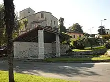
Kirche Saint-Pierre im Hintergrund
Weblinks
Commons: Orthevielle – Sammlung von Bildern, Videos und Audiodateien
This article is issued from Wikipedia. The text is licensed under Creative Commons - Attribution - Sharealike. The authors of the article are listed here. Additional terms may apply for the media files, click on images to show image meta data.