Newry and Mourne
Newry and Mourne (irisch An tIúir agus Múrna) war einer der 26 nordirischen Districts, die von 1973 bis 2015 bestanden. Der District lag auf dem Gebiet der traditionellen Grafschaften Armagh und Down. Bedeutende Orte waren die Stadt Newry, die auch Verwaltungssitz war, sowie Crossmaglen, Bessbrook, Warrenpoint, Rostrevor, Hilltown, Annalong and Kilkeel. Zum 1. April 2015 ging er im neuen District Newry, Mourne and Down auf.
| Newry and Mourne District Ceantar an Iúir agus Mhúrn | |
|---|---|
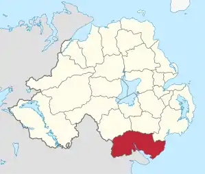 Lage in Nordirland | |
| Geografie | |
| Traditionelle Grafschaften | County Armagh County Down |
| Fläche | 902 km² |
| Verwaltungssitz | Newry |
| ISO 3166-2 | GB-NYM |
| Demografie | |
| Bevölkerung | 100.858 (2012)[1] |
| Dichte | 112 Ew./km² |
| Konfessionen | Protestanten: 15,2 % Katholiken: 72,1 %[2] |
Newry and Mourne Council
Die Wahl zum Newry and Mourne Council am 11. Mai 2011 hatte folgendes Ergebnis:[3]
| Partei | Ergebnis 2011 | Veränderung zu 2005 | |||
|---|---|---|---|---|---|
| Sitze | Stimmen | Sitze | Stimmen | ||
| Sinn Féin | 14 | 45,2 % | 1 | 3,1 % | |
| Social Democratic and Labour Party (SDLP) | 9 | 28,9 % | 0 | −0,6 % | |
| Ulster Unionist Party (UUP) | 3 | 10,3 % | 0 | −0,5 % | |
| United Kingdom Independence Party | 1 | 4,8 % | 1 | 4,8 % | |
| Democratic Unionist Party (DUP) | 1 | 3,0 % | −1 | −3,7 % | |
| Green Party | 0 | 1,0 % | −1 | −1,1 % | |
| Traditional Unionist Voice | 0 | 1,0 % | 0 | 1,0 % | |
| Unabhängige | 2 | 5,6 % | 0 | −3,2 % | |
Einzelnachweise
- Northern Ireland Population Estimates 2012 (XLS-Datei)
- Northern Ireland Census 2011: Religion (administrative geographies)
- Wahlergebnis bei BBC News (Abgerufen am 26. Juli 2011)
Antrim | Ards | Armagh | Ballymena | Ballymoney | Banbridge | Belfast | Carrickfergus | Castlereagh | Coleraine | Cookstown | Craigavon | Derry | Down | Dungannon and South Tyrone | Fermanagh | Larne | Limavady | Lisburn | Magherafelt | Moyle | Newry and Mourne | Newtownabbey | North Down | Omagh | Strabane