Ards
Ards (irisch: An Aird) war einer der 26 nordirischen Districts, die von 1973 bis 2015 bestanden. Der District, dessen Gebiet in der traditionellen Grafschaft Down lag, besaß den Status eines Borough. Er lag an der nordirischen Ostküste und umschloss die Bucht Strangford Lough. Benannt wurde der District nach der Ards-Halbinsel, die einen Teil des Districtgebietes bildete. Der Verwaltungssitz war in Newtownards. Weitere bedeutende Orte im Borough waren Portaferry, Comber und Donaghadee. Zum 1. April 2015 ging er im neuen District Ards and North Down auf.
| Ards Borough Buirg na hArda | |
|---|---|
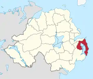 Lage in Nordirland | |
| Geografie | |
| Traditionelle Grafschaft | County Down |
| Fläche | 376 km² |
| Verwaltungssitz | Newtownards |
| ISO 3166-2 | GB-ARD |
| Demografie | |
| Bevölkerung | 78.550 (2012)[1] |
| Dichte | 209 Ew./km² |
| Konfessionen | Protestanten 65,5 % Katholiken 10,9 %[2] |
Ards Borough Council
Die Wahl zum Ards Borough Council am 11. Mai 2011 hatte folgendes Ergebnis:[3]
| Partei | Ergebnis 2011 | Veränderung zu 2005 | |||
|---|---|---|---|---|---|
| Sitze | Stimmen | Sitze | Stimmen | ||
| Democratic Unionist Party (DUP) | 11 | 47,4 % | −1 | −5,0 % | |
| Ulster Unionist Party (UUP) | 6 | 17,5 % | −1 | −7,0 % | |
| Alliance Party | 4 | 18,2 % | +1 | 4,2 % | |
| Social Democratic and Labour Party (SDLP) | 1 | 6,8 % | 0 | 3,4 % | |
| Traditional Unionist Voice | 0 | 3,4 % | 0 | 3,4 % | |
| Green Party | 0 | 0,8 % | 0 | 0,1 % | |
| Sonstige | 0 | 0,5 % | 0 | 0,5 % | |
| Unabhängige | 1 | 5,4 % | 1 | 1,6 % | |
Die Megalithanlage von Millin Bay liegt auf der Halbinsel.
Siehe auch
Einzelnachweise
- Northern Ireland Population Estimates 2012 (XLS-Datei)
- Northern Ireland Census 2011: Religion (administrative geographies)
- Wahlergebnis bei BBC News (Abgerufen am 26. Juli 2011)
Antrim | Ards | Armagh | Ballymena | Ballymoney | Banbridge | Belfast | Carrickfergus | Castlereagh | Coleraine | Cookstown | Craigavon | Derry | Down | Dungannon and South Tyrone | Fermanagh | Larne | Limavady | Lisburn | Magherafelt | Moyle | Newry and Mourne | Newtownabbey | North Down | Omagh | Strabane