Manitoba Census Division No. 22
Die Census Division No. 22 in der kanadischen Provinz Manitoba gehört zur Northern Region. Sie hat eine Fläche von 92.068,5 km² und 42.165 Einwohner (Stand: 2016). 2011 betrug die Einwohnerzahl 40.923.[2]
| Division No. 22 | |
|---|---|
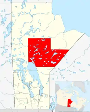 Lage der Region in Manitoba | |
| Basisdaten | |
| Staat | Kanada |
| Provinz | Manitoba |
| Koordinaten: | 54° 38′ N, 96° 26′ W |
| Einwohner | 42.165 (Stand: 2016[1]) |
| Fläche | 92.068,5 km² |
| Bevölkerungsdichte | 0,5 Einw./km² |
| Zeitzone: | Central Standard Time (UTC−6) Central Daylight Time (UTC−5, Sommerzeit) |

Gemeinden
City
Örtlicher Verwaltungsdistrikt
- Mystery Lake
Unorganized Area
- Manitoba Unorganized Area No. 22
Indianerreservate
Cross Lake First Nation
- Cross Lake 19
- Cross Lake 19A
- Cross Lake 19B
- Cross Lake 19C
- Cross Lake 19E
Garden Hill First Nation
- Garden Hill
God's Lake First Nation
- God's Lake Narrows 23
Ilford
Manto Sipi Cree Nation
- God's River 86A
Nisichawayasihk Cree Nation
- Nelson House 170
Norway House Cree Nation
- Norway House 17
Bunibonibee Cree Nation
- Oxford House 24
Red Sucker Lake First Nation
- Red Sucker Lake 1976
St. Theresa Point First Nation
- St. Theresa Point
Tataskweyak Cree Nation
- Split Lake 171
Wasagamack First Nation
- Wasagamack
- York Factory
Einzelnachweise
- Statistics Canada: Census Profile, 2016 Census – Division No. 22, Census division (Census division), Manitoba and Alberta (Province), abgerufen am 15. Mai 2021
- Statistics Canada: Census 2011. Abgerufen am 29. Juli 2012 (englisch).
Weblinks
- Census Profile: Census Division No. 22, Manitoba; Statistics Canada
- Census Profile: Karte Census Division No. 22, Manitoba; Statistics Canada
Division No. 1 | Division No. 2 | Division No. 3 | Division No. 4 | Division No. 5 | Division No. 6 | Division No. 7 | Division No. 8 | Division No. 9 | Division No. 10 | Division No. 11 | Division No. 12 | Division No. 13 | Division No. 14 | Division No. 15 | Division No. 16 | Division No. 17 | Division No. 18 | Division No. 19 | Division No. 20 | Division No. 21 | Division No. 22 | Division No. 23