Mártély
Mártély ist eine ungarische Gemeinde im Kreis Hódmezővásárhely im Komitat Csongrád-Csanád. Sie liegt an einem toten Arm der Theiß. Mártély hat 1301 Einwohner (Stand 2015).
| Mártély | |||||
| |||||
| Basisdaten | |||||
|---|---|---|---|---|---|
| Staat: | Ungarn | ||||
| Region: | Südliche Große Tiefebene | ||||
| Komitat: | Csongrád-Csanád | ||||
| Kleingebiet bis 31.12.2012: | Hódmezővásárhely | ||||
| Kreis seit 1.1.2013: | Hódmezővásárhely | ||||
| Koordinaten: | 46° 28′ N, 20° 14′ O | ||||
| Fläche: | 36,45 km² | ||||
| Einwohner: | 1.349 (1. Jan. 2011) | ||||
| Bevölkerungsdichte: | 37 Einwohner je km² | ||||
| Telefonvorwahl: | (+36) 62 | ||||
| Postleitzahl: | 6636 | ||||
| KSH-kód: | 25733 | ||||
| Struktur und Verwaltung (Stand: 2020) | |||||
| Gemeindeart: | Gemeinde | ||||
| Bürgermeisterin: | Anita Putz[1] (parteilos) | ||||
| Postanschrift: | Rákóczi tér 1 6636 Mártély | ||||
| Website: | |||||
| (Quelle: A Magyar Köztársaság helységnévkönyve 2011. január 1. bei Központi statisztikai hivatal) | |||||


Gemeindepartnerschaften
 Verbandsgemeinde Altenahr, Deutschland
 Detk, Ungarn
 Eremitu, Rumänien
 Trešnjevac (Трешњевац), Serbien
Sehenswürdigkeiten
- Landschaftsschutzgebiet an der Theiß
- Römisch-katholische Kirche Szent Adorján, erbaut 1910–1911
- Windmühle (Késmárki Imre-féle szélmalom)
Verkehr
Durch Mártély verläuft die Landstraße Nr. 4521. Die Gemeinde ist angebunden an die Eisenbahnstrecke von Szentes nach Hódmezővásárhely.
Bilder
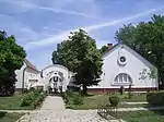 Gemeindeverwaltung in Mártély
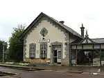 Bahnhof in Mártély
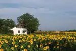 Altes Bauernhaus in Mártély
Einzelnachweise
- Helyi önkormányzati választások 2019 - Mártély (Csongrád megye). Nemzeti Választási Iroda, 13. Oktober 2019, abgerufen am 13. Juni 2020 (ungarisch).
Weblinks
- Offizielle Website (ungarisch)
This article is issued from Wikipedia. The text is licensed under Creative Commons - Attribution - Sharealike. The authors of the article are listed here. Additional terms may apply for the media files, click on images to show image meta data.