Lureuil
Lureuil ist eine westfranzösische Gemeinde mit 257 Einwohnern (Stand: 1. Januar 2019) im Département Indre in der Region Centre-Val de Loire. Die Gemeinde gehört zum Arrondissement Le Blanc und zum Kanton Le Blanc (bis 2015: Kanton Tournon-Saint-Martin).
| Lureuil | ||
|---|---|---|
| ||
| Staat | Frankreich | |
| Region | Centre-Val de Loire | |
| Département (Nr.) | Indre (36) | |
| Arrondissement | Le Blanc | |
| Kanton | Le Blanc | |
| Gemeindeverband | Brenne-Val de Creuse | |
| Koordinaten | 46° 45′ N, 0° 57′ O | |
| Höhe | 90–151 m | |
| Fläche | 22,16 km² | |
| Einwohner | 257 (1. Januar 2019) | |
| Bevölkerungsdichte | 12 Einw./km² | |
| Postleitzahl | 36220 | |
| INSEE-Code | 36105 | |
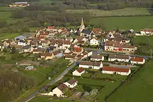 Blick auf Lureuil | ||

Lage
Lureuil liegt etwa 45 Kilometer ostnordöstlich von Poitiers. Umgeben wird Lureuil von den Nachbargemeinden Martizay im Norden, Lingé im Osten, Douadic im Südosten, Pouligny-Saint-Pierre im Süden, Tournon-Saint-Martin im Westen sowie Bossay-sur-Claise im Nordwesten.
Bevölkerungsentwicklung
| Jahr | 1962 | 1968 | 1975 | 1982 | 1990 | 1999 | 2006 | 2013 |
| Einwohner | 336 | 302 | 222 | 215 | 281 | 287 | 275 | 267 |
| Quelle: Cassini und INSEE | ||||||||
Sehenswürdigkeiten
- Kirche Saint-Jean-Baptiste aus dem 19. Jahrhundert
- Schloss Pazereux
- Schloss La Brosse aus dem 19. Jahrhundert
Weblinks
Commons: Lureuil – Sammlung von Bildern, Videos und Audiodateien
This article is issued from Wikipedia. The text is licensed under Creative Commons - Attribution - Sharealike. The authors of the article are listed here. Additional terms may apply for the media files, click on images to show image meta data.