Louzy
Louzy ist eine französische Gemeinde mit 1.320 Einwohnern (Stand: 1. Januar 2019) im Département Deux-Sèvres in der Region Nouvelle-Aquitaine. Die Gemeinde gehört zum Arrondissement Bressuire und zum Kanton Thouars (bis 2015 gehörte die Gemeinde zum Kanton Thouars-2).
| Louzy | ||
|---|---|---|
| ||
| Staat | Frankreich | |
| Region | Nouvelle-Aquitaine | |
| Département (Nr.) | Deux-Sèvres (79) | |
| Arrondissement | Bressuire | |
| Kanton | Thouars | |
| Gemeindeverband | Thouarsais | |
| Koordinaten | 47° 1′ N, 0° 11′ W | |
| Höhe | 42–81 m | |
| Fläche | 18,58 km² | |
| Einwohner | 1.320 (1. Januar 2019) | |
| Bevölkerungsdichte | 71 Einw./km² | |
| Postleitzahl | 79100 | |
| INSEE-Code | 79157 | |
| Website | http://www.mairielouzy.free.fr/ | |

Lage
Louzy liegt etwa 30 Kilometer nordöstlich von Bressuire im Weinbaugebiet Anjou. Umgeben wird Louzy von den Nachbargemeinden Brion-près-Thouet im Norden, Saint-Cyr-la-Lande im Nordosten, Saint-Léger-de-Montbrun im Osten und Südosten, Thouars im Süden und Südwesten, Sainte-Verge im Westen sowie Saint-Martin-de-Sanzay im Nordwesten.
Bevölkerungsentwicklung
| Jahr | 1962 | 1968 | 1975 | 1982 | 1990 | 1999 | 2006 | 2013 |
| Einwohner | 707 | 640 | 732 | 901 | 1.098 | 1.115 | 1.137 | 1.302 |
| Quelle: Cassini und INSEE | ||||||||
Sehenswürdigkeiten
- Kirche Saint-Pierre aus dem 11./12. Jahrhundert
- Taubenturm
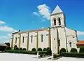 Kirche Saint-Pierre
 Taubenturm
This article is issued from Wikipedia. The text is licensed under Creative Commons - Attribution - Sharealike. The authors of the article are listed here. Additional terms may apply for the media files, click on images to show image meta data.