Le Louverot
Le Louverot ist eine französische Gemeinde im Département Jura in der Region Bourgogne-Franche-Comté. Sie gehört zum Arrondissement Lons-le-Saunier und zum Kanton Poligny.
| Le Louverot | ||
|---|---|---|
.svg.png.webp)
|
| |
| Staat | Frankreich | |
| Region | Bourgogne-Franche-Comté | |
| Département (Nr.) | Jura (39) | |
| Arrondissement | Lons-le-Saunier | |
| Kanton | Poligny | |
| Gemeindeverband | Bresse Haute Seille | |
| Koordinaten | 46° 44′ N, 5° 35′ O | |
| Höhe | 250–340 m | |
| Fläche | 1,75 km² | |
| Einwohner | 222 (1. Januar 2019) | |
| Bevölkerungsdichte | 127 Einw./km² | |
| Postleitzahl | 39210 | |
| INSEE-Code | 39304 | |

Le Louverot grenzt an folgende Gemeinden: Voiteur im Norden, Le Vernois im Osten, Lavigny im Südosten, Montain im Süden, Plainoiseau im Südwesten sowie Domblans im Westen.
Bevölkerungsentwicklung
| Jahr | 1962 | 1968 | 1975 | 1982 | 1990 | 1999 | 2008 | 2017 | |
|---|---|---|---|---|---|---|---|---|---|
| Einwohner | 77 | 91 | 110 | 156 | 256 | 313 | 265 | 211 | |
| Quellen: Cassini und INSEE | |||||||||
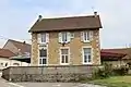 Mairie Le Louverot
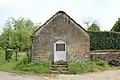 Freifaltigkeits- und Heiliggeist-Kapelle
This article is issued from Wikipedia. The text is licensed under Creative Commons - Attribution - Sharealike. The authors of the article are listed here. Additional terms may apply for the media files, click on images to show image meta data.