Kanton Villefort
Der Kanton Villefort war bis 2015 ein französischer Wahlkreis im Mende, im Département Lozère und in der Region Languedoc-Roussillon; sein Hauptort war Villefort.
| Ehemaliger Kanton Villefort | |
|---|---|
| Region | Languedoc-Roussillon |
| Département | Lozère |
| Arrondissement | Mende |
| Hauptort | Villefort |
| Auflösungsdatum | 29. März 2015 |
| Einwohner | 1.738 (1. Jan. 2012) |
| Bevölkerungsdichte | 8 Einw./km² |
| Fläche | 218.27 km² |
| Gemeinden | 24 |
| INSEE-Code | 4824 |
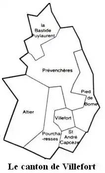
Die Gemeinden im Kanton
Der Kanton Villefort war 218,27 km² groß und hatte 1.649 Einwohner (Stand 1999).
Gemeinden
Der Kanton bestand aus sieben Gemeinden:
| Gemeinde | Einwohner Jahr | Fläche km² | Bevölkerungsdichte | Code INSEE | Postleitzahl |
|---|---|---|---|---|---|
| Altier | 208 (2013) | – | – Einw./km² | 48004 | 48800 |
| La Bastide-Puylaurent | 179 (2013) | – | – Einw./km² | 48021 | 48250 |
| Pied-de-Borne | 216 (2013) | – | – Einw./km² | 48015 | 48800 |
| Pourcharesses | 111 (2013) | – | – Einw./km² | 48117 | 48800 |
| Prévenchères | 261 (2013) | – | – Einw./km² | 48119 | 48800 |
| Saint-André-Capcèze | 167 (2013) | – | – Einw./km² | 48135 | 48800 |
| Villefort | 604 (2013) | – | – Einw./km² | 48198 | 48800 |
This article is issued from Wikipedia. The text is licensed under Creative Commons - Attribution - Sharealike. The authors of the article are listed here. Additional terms may apply for the media files, click on images to show image meta data.