Kanton Mtsamboro
Der Kanton Mtsamboro ist ein Kanton im französischen Übersee-Département Mayotte. Er besitzt den INSEE-Code 97609.
| Kanton Mtsamboro | |
|---|---|
| Region | Mayotte |
| Département | Mayotte |
| Hauptort | Mtsamboro |
| Einwohner | 16.030 (1. Jan. 2017) |
| Bevölkerungsdichte | 474 Einw./km² |
| Fläche | 33,85 km² |
| Gemeinden | 2 1⁄2 |
| INSEE-Code | 97609 |
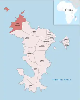 Lage des Kantons Mtsamboro im Département Mayotte | |
Gemeinden
Der Kanton besteht aus zwei Gemeinden und Gemeindeteilen mit insgesamt 16.030 Einwohnern (Stand: 14. Dezember 2017) auf einer Gesamtfläche von 33,85 km²:
| Gemeinde | Einwohner 1. Januar 2019 |
Fläche km² |
Dichte Einw./km² |
Code INSEE |
Postleitzahl |
|---|---|---|---|---|---|
| Acoua | 5.192 | 12,45 | 417 | 97601 | 97630 |
| Bandraboua [A 1] | 3.133 | 5,35 | 586 | 97602 | 97650 |
| Mtsamboro | 7.705 | 16,05 | 480 | 97612 | 97630 |
| Kanton Mtsamboro | 16.030 | 33,85 | 474 | 97609 | – |
- Nur der westliche Teil der Gemeinde, der Rest gehört zum Kanton Bandraboua.
Geschichte
Von 1977 bis 2015 bestand ein gleichnamiger Kanton, der nur das Gebiet der Gemeinde Mtsamboro umfasste. Vertreter im Generalrat von Mayotte war von 2008 bis 2015 Ali Bacar.
This article is issued from Wikipedia. The text is licensed under Creative Commons - Attribution - Sharealike. The authors of the article are listed here. Additional terms may apply for the media files, click on images to show image meta data.