Fontiers-Cabardès
| Fontiers-Cabardès | ||
|---|---|---|
.svg.png.webp)
|
| |
| Staat | Frankreich | |
| Region | Okzitanien | |
| Département (Nr.) | Aude (11) | |
| Arrondissement | Carcassonne | |
| Kanton | La Malepère à la Montagne Noire | |
| Gemeindeverband | Montagne Noire | |
| Koordinaten | 43° 22′ N, 2° 15′ O | |
| Höhe | 438–803 m | |
| Fläche | 8,83 km² | |
| Einwohner | 450 (1. Januar 2019) | |
| Bevölkerungsdichte | 51 Einw./km² | |
| Postleitzahl | 11390 | |
| INSEE-Code | 11150 | |
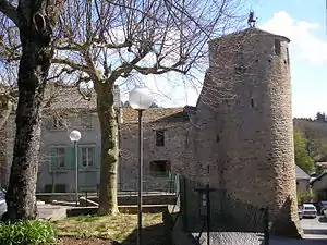 Tour de l’Horloge | ||

Fontiers-Cabardès ist eine französische Gemeinde mit 450 Einwohnern (Stand 1. Januar 2019) im Département Aude in der Region Okzitanien. Sie gehört zum Arrondissement Carcassonne und zum Kanton La Malepère à la Montagne Noire.
Nachbargemeinden
Nachbargemeinden von Fontiers-Cabardès sind Caudebronde im Osten, Les Martys im Südwesten und Laprade im Nordwesten.[1]
Bevölkerungsentwicklung
| Jahr | 1962 | 1968 | 1975 | 1982 | 1990 | 1999 | 2013 |
| Einwohner | 305 | 205 | 245 | 307 | 306 | 324 | 444 |
Sehenswürdigkeiten
- Kirche Saint-Clément (Monument historique)
- Tour de l’Horloge (16. Jahrhundert)
Weblinks
Commons: Fontiers-Cabardès – Sammlung von Bildern, Videos und Audiodateien
This article is issued from Wikipedia. The text is licensed under Creative Commons - Attribution - Sharealike. The authors of the article are listed here. Additional terms may apply for the media files, click on images to show image meta data.