Ennordres
Ennordres ist eine französische Gemeinde mit 212 Einwohnern (Stand: 1. Januar 2019) im Département Cher in der Region Centre-Val de Loire; sie gehört zum Arrondissement Vierzon und zum Kanton Aubigny-sur-Nère (bis 2015: Kanton La Chapelle-d’Angillon).
| Ennordres | ||
|---|---|---|
| ||
| Staat | Frankreich | |
| Region | Centre-Val de Loire | |
| Département (Nr.) | Cher (18) | |
| Arrondissement | Vierzon | |
| Kanton | Aubigny-sur-Nère | |
| Gemeindeverband | Sauldre et Sologne | |
| Koordinaten | 47° 26′ N, 2° 23′ O | |
| Höhe | 154–293 m | |
| Fläche | 64,46 km² | |
| Einwohner | 212 (1. Januar 2019) | |
| Bevölkerungsdichte | 3 Einw./km² | |
| Postleitzahl | 18380 | |
| INSEE-Code | 18088 | |
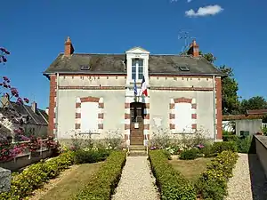 Rathaus (Mairie) von Ennordres | ||

Geographie
Ennordres liegt etwa 29 Kilometer nördlich von Bourges. Umgeben wird Ennordres von den Nachbargemeinden Aubigny-sur-Nère im Norden, Oizon im Osten und Nordosten, Ivoy-le-Pré im Südosten, La Chapelle-d’Angillon im Süden, Presly im Westen und Südwesten, Ménétréol-sur-Sauldre im Westen sowie Sainte-Montaine im Nordwesten.
Bevölkerungsentwicklung
| Jahr | 1962 | 1968 | 1975 | 1982 | 1990 | 1999 | 2006 | 2013 |
| Einwohner | 482 | 396 | 307 | 589 | 242 | 249 | 226 | 217 |
| Quelle: Cassini und INSEE | ||||||||
Sehenswürdigkeiten
- Kirche Saint-Martin aus dem 12. Jahrhundert, seit 1921 Monument historique (siehe auch: Liste der Monuments historiques in Ennordres)
- Kapelle Saint-Georges aus dem 13. Jahrhundert
- Schloss Echeneau aus dem 17. Jahrhundert
- Schloss La Motte aus dem 17. Jahrhundert
- Schloss La Brossette aus dem 18. Jahrhundert
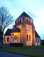
Kirche Saint-Martin
Literatur
- Le Patrimoine des Communes du Cher. Flohic Editions, Band 1, Paris 2001, ISBN 2-84234-088-4, S. 234–237.
This article is issued from Wikipedia. The text is licensed under Creative Commons - Attribution - Sharealike. The authors of the article are listed here. Additional terms may apply for the media files, click on images to show image meta data.