Brossay
Brossay ist eine französische Gemeinde mit 350 Einwohnern (Stand: 1. Januar 2019) im Département Maine-et-Loire in der Region Pays de la Loire. Die Gemeinde gehört zum Arrondissement Saumur und zum Kanton Doué-en-Anjou. Die Einwohner werden Brossayens genannt.
| Brossay | ||
|---|---|---|
| ||
| Staat | Frankreich | |
| Region | Pays de la Loire | |
| Département (Nr.) | Maine-et-Loire (49) | |
| Arrondissement | Saumur | |
| Kanton | Doué-en-Anjou | |
| Gemeindeverband | Saumur Val de Loire | |
| Koordinaten | 47° 10′ N, 0° 13′ W | |
| Höhe | 55–94 m | |
| Fläche | 4,81 km² | |
| Einwohner | 350 (1. Januar 2019) | |
| Bevölkerungsdichte | 73 Einw./km² | |
| Postleitzahl | 49700 | |
| INSEE-Code | 49053 | |

Lage
Brossay liegt etwa 55 Kilometer südöstlich von Angers. Umgeben wird Brossay von den Nachbargemeinden Doué-en-Anjou im Norden und Westen, Cizay-la-Madeleine im Osten und Nordosten sowie Vaudelnay im Süden.
Bevölkerungsentwicklung
| Jahr | 1962 | 1968 | 1975 | 1982 | 1990 | 1999 | 2006 | 2018 |
| Einwohner | 206 | 289 | 337 | 280 | 300 | 243 | 290 | 357 |
| Quellen: Cassini und INSEE | ||||||||
Sehenswürdigkeiten
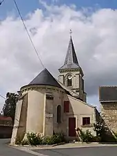
Kirche Saint-Nicolas
- Kirche Saint-Nicolas
Weinbau
Die Reben in Brossay gehören zum Weinbaugebiet Anjou.
Literatur
- Le Patrimoine des Communes de Maine-et-Loire. Flohic Editions, Band 2, Paris 2001, ISBN 2-84234-117-1, S. 821–822.
Weblinks
Commons: Brossay – Sammlung von Bildern, Videos und Audiodateien
- Monuments historiques (Objekte) in Brossay in der Base Palissy des französischen Kultusministeriums
This article is issued from Wikipedia. The text is licensed under Creative Commons - Attribution - Sharealike. The authors of the article are listed here. Additional terms may apply for the media files, click on images to show image meta data.