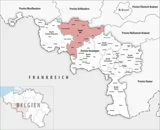
Bezirk Ath
Der Bezirk Ath (französisch arrondissement administratif d'Ath) ist einer von sieben Verwaltungsbezirken in der belgischen Provinz Hennegau. Er umfasst eine Fläche von 667,94 km² mit 128.468 Einwohnern (Stand: 1. Januar 2020[1]) in elf Gemeinden.
| Bezirk Ath | |
|---|---|
| Region | Wallonien |
| Provinz | Hennegau |
| Einwohner | 128.468 (1. Jan. 2020) |
| Bevölkerungsdichte | 192 Einw./km² |
| Fläche | 667,94 km² |
| Gemeinden | 11 |
| NIS-Code | 51000 |
 Lage des Bezirks Ath in der Provinz Hennegau | |
Gemeinden im Bezirk Ath
| Gemeinde | Einwohner 1. Januar 2020 |
Fläche km² |
Dichte Einw./km² |
NIS- Code |
Postleitzahl |
|---|---|---|---|---|---|
| Ath | 29.494 | 126,95 | 232 | 51004 | 7800, 7801, 7802, 7803, 7804, 7810, 7811, 7812. 7822, 7823 |
| Belœil | 14.060 | 61,55 | 228 | 51008 | 7970, 7971, 7972, 7973 |
| Bernissart | 11.852 | 43,42 | 273 | 51009 | 7320, 7321, 7322 |
| Brugelette | 3.724 | 28,40 | 131 | 51012 | 7940, 7941, 7942, 7943 |
| Chièvres | 6.925 | 46,91 | 148 | 51014 | 7950, 7951 |
| Ellezelles | 5.992 | 44,69 | 134 | 51017 | 7890 |
| Enghien | 14.061 | 40,59 | 346 | 51067 | 7850 |
| Flobecq | 3.433 | 23,02 | 149 | 51019 | 7880 |
| Frasnes-lez-Anvaing | 11.833 | 112,44 | 105 | 51065 | 7910, 7911, 7912 |
| Lessines | 18.746 | 72,29 | 259 | 51069 | 7860, 7861, 7862, 7863, 7864, 7866 |
| Silly | 8.348 | 67,88 | 123 | 51068 | 7830 |
| Bezirk Ath | 128.468 | 667,94 | 192 | 51000 | – |
Siehe auch
Einzelnachweise
- Mouvement de la population en 2020. (XLSX; 2,56 MB) In: statbel.fgov.be. Statbel – Direction générale Statistique – Statistics Belgium (Föderaler Öffentlicher Dienst), abgerufen am 4. Juli 2021 (französisch).
This article is issued from Wikipedia. The text is licensed under Creative Commons - Attribution - Sharealike. The authors of the article are listed here. Additional terms may apply for the media files, click on images to show image meta data.