Arrondissement Saint-Pierre (Martinique)
Das Arrondissement Saint-Pierre ist eine Verwaltungseinheit des französischen Départements Martinique. Hauptort (Unterpräfektur) ist Saint-Pierre.
| Arrondissement Saint-Pierre | |
|---|---|
| Region | Martinique |
| Département | Martinique |
| Unterpräfektur | Saint-Pierre |
| Einwohner | 22.344 (1. Jan. 2019) |
| Bevölkerungsdichte | 117 Einw./km² |
| Fläche | 191,27 km² |
| Gemeinden | 8 |
| INSEE-Code | 9724 |
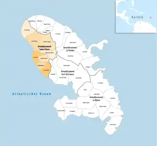
 Lage des Arrondissements Saint-Pierre im Département Martinique | |
Es wurde zum 1. Juni 1995 aus Teilen des Arrondissements Fort-de-France gebildet.[1]
Einwohnerentwicklung
| 1967 | 1974 | 1982 | 1990 | 1999 | 2006 |
|---|---|---|---|---|---|
| 24.090 | 23.278 | 21.178 | 23.336 | 23.436 | 23.807 |
Gemeinden
Die 8 Gemeinden des Arrondissements Saint-Pierre sind:
| Gemeinde | Einwohner 1. Januar 2019 |
Fläche km² |
Dichte Einw./km² |
Code INSEE |
Postleitzahl |
|---|---|---|---|---|---|
| Bellefontaine | 1.813 | 11,81 | 154 | 97234 | 97222 |
| Case-Pilote | 4.455 | 18,62 | 239 | 97205 | 97222 |
| Fonds-Saint-Denis | 680 | 23,67 | 29 | 97208 | 97250 |
| Le Carbet | 3.461 | 17,77 | 195 | 97204 | 97221 |
| Le Morne-Rouge | 4.795 | 37,55 | 128 | 97218 | 97260 |
| Le Morne-Vert | 1.816 | 13,32 | 136 | 97233 | 97226 |
| Le Prêcheur | 1.203 | 29,97 | 40 | 97219 | 97250 |
| Saint-Pierre | 4.121 | 38,56 | 107 | 97225 | 97250 |
| Arrondissement Saint-Pierre | 22.344 | 191,27 | 117 | 9724 | – |
Kantone
Bis 2015 bestanden im Arrondissement Saint-Pierre die folgenden 5 Kantone:
Einzelnachweise
This article is issued from Wikipedia. The text is licensed under Creative Commons - Attribution - Sharealike. The authors of the article are listed here. Additional terms may apply for the media files, click on images to show image meta data.