Rodeiro (Pontevedra)
Rodeiro ist eine galicische Gemeinde in der Provinz Pontevedra im Nordwesten Spaniens mit 2437 Einwohnern (Stand 2019).
| Rodeiro | |||
|---|---|---|---|
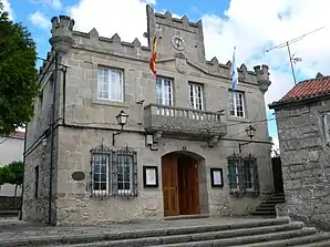 Rathaus | |||
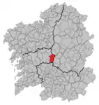
| Wappen | Karte von Spanien | ||
 |
| ||
| Basisdaten | |||
| Autonome Gemeinschaft: | |||
| Provinz: | Pontevedra | ||
| Koordinaten | 42° 39′ N, 7° 57′ W | ||
| Höhe: | 660 msnm | ||
| Fläche: | 154,9 km² | ||
| Einwohner: | 2.437 (1. Jan. 2019)[1] | ||
| Bevölkerungsdichte: | 15,73 Einw./km² | ||
| Postleitzahl: | 36530 | ||
| Gemeindenummer (INE): | 36047 | ||
| Verwaltung | |||
| Website: | www.rodeiro.gal | ||
| Lage der Stadt | |||
 | |||

Gliederung
Die Gemeinde ist in die folgenden Parroquias gegliedert:
- Álceme (Santa María)
- Arnego (Santiago)
- Asperelo (San Martín)
- Az (San Cristóbal)
- Camba (San Juan)
- Carboentes (San Esteban)
- Fafián (Santiago)
- Guillar (Santa María)
- Negrelos (San Ciprián)
- Pedroso (San Julián)
- Pescoso (Santa Mariña)
- Portela (San Cristóbal)
- Río (Santa María)
- Riobó (San Miguel)
- Rodeiro (San Vicente)
- Salto (San Esteban)
- San Salvador de Camba (San Salvador)
- Santa Eulalia de Camba (Santa Eulalia)
- Senra (San Pelayo)
- Vilela (Santa María)
Bevölkerungsentwicklung
| Jahr | 1842 | 1900 | 1950 | 1981 | 1991 | 2001 | 2011 |
|---|---|---|---|---|---|---|---|
| Einwohner | 3 188 | 7 433 | 10 163 | 4 797 | 4 956 | 4 229 | 2 920 |
| Quelle: INE[2] | |||||||
Weblinks
Einzelnachweise
- Cifras oficiales de población resultantes de la revisión del Padrón municipal a 1 de enero. Bevölkerungsstatistiken des Instituto Nacional de Estadística (Bevölkerungsfortschreibung).
- INEbase. Alteraciones de los municipios. Abgerufen am 6. Juni 2021.
Agolada | Arbo | Baiona | Barro | Bueu | Caldas de Reis | Cambados | Campo Lameiro | Cangas | A Cañiza | Catoira | Cerdedo-Cotobade | Covelo | Crecente | Cuntis | Dozón | A Estrada | Forcarei | Fornelos de Montes | Gondomar | O Grove | A Guarda | A Illa de Arousa | Lalín | A Lama | Marín | Meaño | Meis | Moaña | Mondariz | Mondariz-Balneario | Moraña | Mos | As Neves | Nigrán | Oia | Pazos de Borbén | Poio | Ponte Caldelas | Ponteareas | Pontecesures | Pontevedra | O Porriño | Portas | Redondela | Ribadumia | Rodeiro | O Rosal | Salceda de Caselas | Salvaterra de Miño | Sanxenxo | Silleda | Soutomaior | Tomiño | Tui | Valga | Vigo | Vila de Cruces | Vilaboa | Vilagarcía de Arousa | Vilanova de Arousa