Regional District of Kitimat-Stikine
Der Regional District of Kitimat-Stikine ist ein Bezirk in der kanadischen Provinz British Columbia. Er ist 104.464,61 km² groß und zählt 37.367 Einwohner (2016).[1] Beim Zensus 2011 wurden für den Bezirk 37.361 Einwohner ermittelt. Hauptort ist Terrace.
| Kitimat-Stikine | |
|---|---|
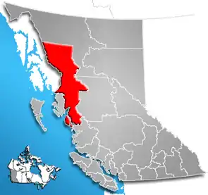 Lage der Region in British Columbia | |
| Basisdaten | |
| Staat | Kanada |
| Provinz | British Columbia |
| Verwaltungssitz | Terrace |
| Koordinaten: | 55° 20′ N, 129° 0′ W |
| Einwohner | 37.367 (Stand: 2016) |
| Fläche | 104.464,61 km² |
| Bevölkerungsdichte | 0,4 Einw./km² |
| Zeitzone: | Pacific Standard Time (UTC−8) Pacific Daylight Time (UTC−7, Sommerzeit) |
| Webpräsenz | www.rdks.bc.ca |
Der Bezirk wurde am 14. September 1967 gegründet.[2] Ein Teil des Bezirks um Banks Island und Pitt Island wurde am 19. August 1993 an den heutigen North Coast Regional District abgetreten.
Administrative Gliederung
Städte und Gemeinden
| Ort | Status | Bevölkerung[3] |
| Hazelton | Village | 313 |
| Kitimat | District municipality | 8.131 |
| New Hazelton | District municipality | 580 |
| Stewart | District municipality | 401 |
| Terrace | City | 11.643 |
Gemeindefreie Gebiete
- Kitimat-Stikine A
- Kitimat-Stikine B
- Kitimat-Stikine C
- Kitimat-Stikine D
Weblinks
- Offizielle Seite
- Karte mit Grenzen herausgegeben von der Provinz (englisch)
Einzelnachweise
- Census Profile, 2016 Census. 16. November 2017, abgerufen am 12. März 2018 (englisch).
- Origin Notes and History. Regional District of Kitimat-Stikine. GeoBC, abgerufen am 15. Februar 2021 (englisch).
- Census Profile, 2016 Census - Provincial Data. 9. August 2019, abgerufen am 9. August 2019 (englisch).
Alberni-Clayoquot | Bulkley-Nechako | Capital | Cariboo | Central Coast | Central Kootenay | Central Okanagan | Columbia-Shuswap | Comox Valley | Cowichan Valley | East Kootenay | Fraser Valley | Fraser-Fort George | Kitimat-Stikine | Kootenay Boundary | Metro Vancouver | Mount Waddington | Nanaimo | North Coast | North Okanagan | Northern Rockies | Okanagan-Similkameen | Peace River | qathet | Squamish-Lillooet | Stikine | Strathcona | Sunshine Coast | Thompson-Nicola