Pamlény
Pamlény ist eine Gemeinde im Komitat Borsod-Abaúj-Zemplén in Ungarn.
| Pamlény | |||||
| |||||
| Basisdaten | |||||
|---|---|---|---|---|---|
| Staat: | Ungarn | ||||
| Region: | Nordungarn | ||||
| Komitat: | Borsod-Abaúj-Zemplén | ||||
| Kleingebiet bis 31.12.2012: | Encs | ||||
| Kreis seit 1.1.2013: | Szikszó | ||||
| Koordinaten: | 48° 30′ N, 20° 56′ O | ||||
| Höhe: | 223 m | ||||
| Fläche: | 12,4 km² | ||||
| Einwohner: | 51 (1. Jan. 2011) | ||||
| Bevölkerungsdichte: | 4 Einwohner je km² | ||||
| Telefonvorwahl: | (+36) 46 | ||||
| Postleitzahl: | 3821 | ||||
| KSH-kód: | 12371 | ||||
| Struktur und Verwaltung (Stand: 2013) | |||||
| Gemeindeart: | Gemeinde | ||||
| Bürgermeisterin: | Gyuláné Zsarnai (parteilos) | ||||
| Postanschrift: | Petőfi út 30. 3821 Pamlény | ||||
| (Quelle: A Magyar Köztársaság helységnévkönyve 2011. január 1. bei Központi statisztikai hivatal) | |||||


Geografische Lage
Pamlény liegt im Norden Ungarns, 50 km nördlich von Miskolc entfernt, an dem Bach Janka-patak. Nachbargemeinden sind Keresztéte 8 km, Krasznokvajda 8 km und Szászfa 4 km. Die nächste Stadt Encs ist 30 km von Pamlény entfernt.
Sehenswürdigkeiten
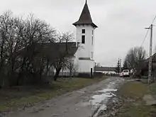
Reformierte Kirche in Pamlény
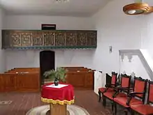
Innenraum der Kirche
- Reformierte Kirche, erbaut 1778
Weblinks
- A pamlényi református templom. Tiszáninneni Református Egyházkerület, abgerufen am 3. Mai 2013 (ungarisch).
- Pamlény. Térképcentrum, abgerufen am 5. April 2013 (ungarisch).
This article is issued from Wikipedia. The text is licensed under Creative Commons - Attribution - Sharealike. The authors of the article are listed here. Additional terms may apply for the media files, click on images to show image meta data.