Nová Lehota
Nová Lehota (bis 1927 slowakisch „Nová Lehôta“; deutsch Neulehota – älter auch Neuhau, ungarisch Újszabadi – bis 1907 Újlehota) ist eine Gemeinde in der Westslowakei.
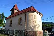
Ortskirche
| Nová Lehota | |||
|---|---|---|---|
| Wappen | Karte | ||
 |
| ||
| Basisdaten | |||
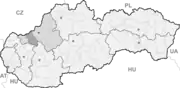
| Staat: | Slowakei | ||
| Kraj: | Trenčiansky kraj | ||
| Okres: | Nové Mesto nad Váhom | ||
| Region: | Dolné Považie | ||
| Fläche: | 18,21 km² | ||
| Einwohner: | 200 (31. Dez. 2020) | ||
| Bevölkerungsdichte: | 11 Einwohner je km² | ||
| Höhe: | 450 m n.m. | ||
| Postleitzahl: | 916 35 | ||
| Telefonvorwahl: | 0 33 | ||
| Geographische Lage: | 48° 39′ N, 17° 59′ O | ||
| Kfz-Kennzeichen: | NM | ||
| Kód obce: | 506311 | ||
| Struktur | |||
| Gemeindeart: | Gemeinde | ||
| Verwaltung (Stand: Mai 2019) | |||
| Bürgermeister: | Dominika Plačková Uhrinová | ||
| Adresse: | Obecný úrad Nová Lehota 50 91635 Modrová | ||
| Statistikinformation auf statistics.sk | |||
Der Ort wurde 1348 zum ersten Mal genannt und liegt zirka 22 Kilometer südöstlich der Stadt Nové Mesto nad Váhom im Gebirge Inowetz.
Weblinks
Commons: Nová Lehota – Sammlung von Bildern, Videos und Audiodateien
- Eintrag auf e-obce.sk (slowakisch)
This article is issued from Wikipedia. The text is licensed under Creative Commons - Attribution - Sharealike. The authors of the article are listed here. Additional terms may apply for the media files, click on images to show image meta data.