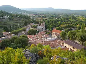
Mazaugues
Mazaugues ist eine französische Gemeinde mit 868 Einwohnern (Stand 1. Januar 2019) im Département Var in der Region Provence-Alpes-Côte d’Azur. Sie gehört zum Arrondissement Brignoles und zum Kanton Garéoult.
| Mazaugues | ||
|---|---|---|
.svg.png.webp)
|
| |
| Staat | Frankreich | |
| Region | Provence-Alpes-Côte d’Azur | |
| Département (Nr.) | Var (83) | |
| Arrondissement | Brignoles | |
| Kanton | Garéoult | |
| Gemeindeverband | Communauté de communes du Val d’Issole | |
| Koordinaten | 43° 21′ N, 5° 55′ O | |
| Höhe | 312–1055 m | |
| Fläche | 53,63 km² | |
| Einwohner | 868 (1. Januar 2019) | |
| Bevölkerungsdichte | 16 Einw./km² | |
| Postleitzahl | 83136 | |
| INSEE-Code | 83076 | |
 Mazaugues | ||

Geographie
Durch Mazaugues fließt der Caramy, im westlichen Gemeindegebiet entspringt der Latay. Das Gemeindegebiet gehört zum Regionalen Naturpark Sainte-Baume. Nachbargemeinden sind Tourves im Norden, La Celle im Nordosten, La Roquebrussanne im Osten, Signes im Süden, Plan-d’Aups-Sainte-Baume und Nans-les-Pins im Westen sowie Rougiers im Nordwesten.
Bevölkerungsentwicklung
| 1962 | 1968 | 1975 | 1982 | 1990 | 1999 | 2006 | 2011 |
|---|---|---|---|---|---|---|---|
| 338 | 365 | 331 | 359 | 461 | 511 | 673 | 838 |
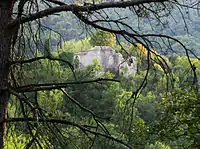 Schloss von Mazaugues
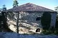 Eisspeicher Glacière de Gaudin, Monument historique
Weblinks
Commons: Mazaugues – Sammlung von Bildern, Videos und Audiodateien
This article is issued from Wikipedia. The text is licensed under Creative Commons - Attribution - Sharealike. The authors of the article are listed here. Additional terms may apply for the media files, click on images to show image meta data.