Locatello
Locatello ist eine italienische Gemeinde (comune) mit 831 Einwohnern (Stand 31. Dezember 2019) in der Provinz Bergamo, Region Lombardei.
| Locatello | ||
|---|---|---|
 |
| |
| Staat | Italien | |
| Region | Lombardei | |
| Provinz | Bergamo (BG) | |
| Koordinaten | 45° 50′ N, 9° 32′ O | |
| Höhe | 557 m s.l.m. | |
| Fläche | 3,75 km² | |
| Einwohner | 831 (31. Dez. 2019)[1] | |
| Fraktionen | Piazzola, Cà Prospero, Cà Marosio, Botta, Mus, Cà Felisa, Medile, Sassi, Disdiroli, Castelleno, Coegia, Fucine, Cantù, Bustoseta, Buonanome, Fiorinello, Follo, Cà Persico | |
| Postleitzahl | 24030 | |
| Vorwahl | 035 | |
| ISTAT-Nummer | 016127 | |
| Volksbezeichnung | Locatellesi | |
| Schutzpatron | Santa Maria Assunta | |
| Website | comune.locatello.bg.it | |
Geographie
Locatello liegt 20 km nordwestlich der Provinzhauptstadt Bergamo und 50 km nordöstlich der Metropole Mailand. Die Nachbargemeinden sind Brumano, Corna Imagna, Fuipiano Valle Imagna und Rota d’Imagna.
Weblinks
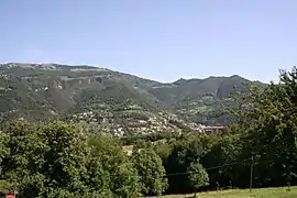 Locatello
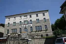 Rathaus
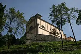 Pfarrkirche Santa Maria Assunta
Einzelnachweise
- Statistiche demografiche ISTAT. Monatliche Bevölkerungsstatistiken des Istituto Nazionale di Statistica, Stand 31. Dezember 2019.

Adrara San Martino | Adrara San Rocco | Albano Sant’Alessandro | Albino | Algua | Almenno San Bartolomeo | Almenno San Salvatore | Almè | Alzano Lombardo | Ambivere | Antegnate | Arcene | Ardesio | Arzago d’Adda | Averara | Aviatico | Azzano San Paolo | Azzone | Bagnatica | Barbata | Bariano | Barzana | Bedulita | Berbenno | Bergamo | Berzo San Fermo | Bianzano | Blello | Bolgare | Boltiere | Bonate Sopra | Bonate Sotto | Borgo di Terzo | Bossico | Bottanuco | Bracca | Branzi | Brembate | Brembate di Sopra | Brignano Gera d’Adda | Brumano | Brusaporto | Calcinate | Calcio | Calusco d’Adda | Calvenzano | Camerata Cornello | Canonica d’Adda | Capizzone | Capriate San Gervasio | Caprino Bergamasco | Caravaggio | Carobbio degli Angeli | Carona | Carvico | Casazza | Casirate d’Adda | Casnigo | Cassiglio | Castel Rozzone | Castelli Calepio | Castione della Presolana | Castro | Cavernago | Cazzano Sant’Andrea | Cenate Sopra | Cenate Sotto | Cene | Cerete | Chignolo d’Isola | Chiuduno | Cisano Bergamasco | Ciserano | Cividate al Piano | Clusone | Colere | Cologno al Serio | Colzate | Comun Nuovo | Corna Imagna | Cornalba | Cortenuova | Costa Valle Imagna | Costa Volpino | Costa di Mezzate | Costa Serina | Covo | Credaro | Curno | Cusio | Dalmine | Dossena | Endine Gaiano | Entratico | Fara Gera d’Adda | Fara Olivana con Sola | Filago | Fino del Monte | Fiorano al Serio | Fontanella | Fonteno | Foppolo | Foresto Sparso | Fornovo San Giovanni | Fuipiano Valle Imagna | Gandellino | Gandino | Gandosso | Gaverina Terme | Gazzaniga | Ghisalba | Gorlago | Gorle | Gorno | Grassobbio | Gromo | Grone | Grumello del Monte | Isola di Fondra | Isso | Lallio | Leffe | Lenna | Levate | Locatello | Lovere | Lurano | Luzzana | Madone | Mapello | Martinengo | Medolago | Mezzoldo | Misano di Gera d’Adda | Moio de’ Calvi | Monasterolo del Castello | Montello | Morengo | Mornico al Serio | Mozzanica | Mozzo | Nembro | Olmo al Brembo | Oltre il Colle | Oltressenda Alta | Oneta | Onore | Orio al Serio | Ornica | Osio Sopra | Osio Sotto | Pagazzano | Paladina | Palazzago | Palosco | Parre | Parzanica | Pedrengo | Peia | Pianico | Piario | Piazza Brembana | Piazzatorre | Piazzolo | Pognano | Ponte Nossa | Ponte San Pietro | Ponteranica | Pontida | Pontirolo Nuovo | Pradalunga | Predore | Premolo | Presezzo | Pumenengo | Ranica | Ranzanico | Riva di Solto | Rogno | Romano di Lombardia | Roncobello | Roncola | Rota d’Imagna | Rovetta | San Giovanni Bianco | San Paolo d’Argon | San Pellegrino Terme | Sant’Omobono Terme | Santa Brigida | Sarnico | Scanzorosciate | Schilpario | Sedrina | Selvino | Seriate | Serina | Solto Collina | Solza | Songavazzo | Sorisole | Sotto il Monte Giovanni XXIII | Sovere | Spinone al Lago | Spirano | Stezzano | Strozza | Suisio | Taleggio | Tavernola Bergamasca | Telgate | Terno d’Isola | Torre Boldone | Torre Pallavicina | Torre de’ Roveri | Trescore Balneario | Treviglio | Treviolo | Ubiale Clanezzo | Urgnano | Val Brembilla | Valbondione | Valbrembo | Valgoglio | Valleve | Valnegra | Valtorta | Vedeseta | Verdellino | Verdello | Vertova | Viadanica | Vigano San Martino | Vigolo | Villa d’Adda | Villa d’Almè | Villa d’Ogna | Villa di Serio | Villongo | Vilminore di Scalve | Zandobbio | Zanica | Zogno