L’Ajoupa-Bouillon
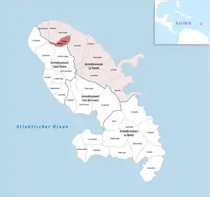
L’Ajoupa-Bouillon (Martinique-Kreolisch: Lajoupabouyon) ist eine französische Gemeinde im Übersee-Département Martinique. Sie befindet sich beim Montagne Pelée und ist 39 km von Fort-de-France entfernt. Die Route de la Trace, eine Route nationale, verbindet die beiden Ortschaften. Die Gemeinde gehörte bis 2015 zum Kanton L’Ajoupa-Bouillon.
| L’Ajoupa-Bouillon | |
|---|---|
 | |
| Staat | Frankreich |
| Region | Martinique |
| Département (Nr.) | Martinique (972) |
| Arrondissement | La Trinité |
| Gemeindeverband | Pays Nord Martinique |
| Koordinaten | 14° 49′ N, 61° 7′ W |
| Höhe | 59–1263 m |
| Fläche | 12,29 km² |
| Einwohner | 1.756 (1. Januar 2019) |
| Bevölkerungsdichte | 143 Einw./km² |
| Postleitzahl | 97216 |
| INSEE-Code | 97201 |
Wirtschaft
Die wirtschaftlichen Schwerpunkte sind die Land- und die Forstwirtschaft.
Bevölkerungsentwicklung
| Jahr | 1961 | 1967 | 1974 | 1982 | 1990 | 1999 | 2008 | 2013 | 2018 |
|---|---|---|---|---|---|---|---|---|---|
| Einwohner[1] | 1647 | 1855 | 1864 | 1731 | 1739 | 1761 | 1691 | 1830 | 1815 |
Weblinks
Commons: L’Ajoupa-Bouillon – Sammlung von Bildern, Videos und Audiodateien
Nachweise
- https://www.insee.fr/fr/statistiques/2011101?geo=COM-97201#chiffre-cle-1 INSEE: Dossier completCommune de l'Ajoupa-Bouillon (97201)
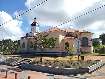
Kirche der Unbefleckten Empfängnis (Église de l'Immaculée-Conception – Monument historique)
This article is issued from Wikipedia. The text is licensed under Creative Commons - Attribution - Sharealike. The authors of the article are listed here. Additional terms may apply for the media files, click on images to show image meta data.