Grenze zwischen Frankreich und Suriname
Die Grenze zwischen Frankreich und Suriname hat eine Länge von 556 Kilometern.[1]
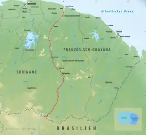
Grenzverlauf Französisch-Guayana-Suriname

Gemeinden an der Staatsgrenze (von Nord nach Süd)
| Suriname |
Frankreich (Französisch-Guayana) | |||||
|---|---|---|---|---|---|---|
| Distrikt | Ressort | Grenz- übertritt |
Grenz- übertritt |
Gemeinde | Arrondissement | |
| Atlantischer Ozean | ||||||
| Marowijne | Galibi | M a r o n i |
Saint-Laurent-du-Maroni | |||
| Albina | ||||||
| Moengo Tapoe | ||||||
| Patamacca | ||||||
| Sipaliwini | Tapanahoni | |||||
| L a w a | ||||||
| Brasilien | ||||||
Weblinks
Commons: Grenze zwischen Frankreich und Suriname – Sammlung von Bildern, Videos und Audiodateien
Einzelnachweise

mit:
![]() Belgien |
Belgien |
![]() Luxemburg |
Luxemburg |
![]() Deutschland |
Deutschland |
![]() Schweiz |
Schweiz |
![]() Italien |
Italien |
![]() Monaco |
Monaco |
![]() Spanien |
Spanien |
![]() Andorra |
Andorra |
![]() Brasilien |
Brasilien |
![]() Suriname |
Suriname |
![]() Niederlande |
Niederlande |
![]() Vereinigtes Königreich
Vereinigtes Königreich

This article is issued from Wikipedia. The text is licensed under Creative Commons - Attribution - Sharealike. The authors of the article are listed here. Additional terms may apply for the media files, click on images to show image meta data.