Gorontalo (Regierungsbezirk)
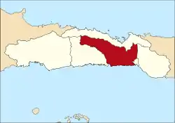
Gorontalo ist ein Regierungsbezirk (Kabupaten) auf der indonesischen Insel Sulawesi. Der Bezirk ist Teil der gleichnamigen Provinz Gorontalo. Hier leben 354.857 Einwohner (2010).
| Kabupaten Gorontalo Regierungsbezirk Gorontalo | ||
|---|---|---|
 | ||
| Symbole | ||
| ||
| Basisdaten | ||
| Staat | Indonesien | |
| Provinz | Sulawesi Barat | |
| Sitz | Limboto | |
| Fläche | 2.124,6 km² | |
| Einwohner | 354.857 (2010) | |
| Dichte | 167 Einwohner pro km² | |
| ISO 3166-2 | ID-GO | |
| Webauftritt | www.gorontalokab.go.id | |
| Politik | ||
| Bupati | Drs. Haji David Bobihoe Akib, M.Sc., M.M. | |
Geographie
Gorontalo hat eine Fläche von 2.124,60 km². Hauptstadt ist Limboto.
Verwaltungsgliederung
Der Bezirk Majene setzt sich aus 17 administrativen Distrikten (Kecamatan), 12 Kelurahan und 157 Dörfern (Desa) zusammen (Stand 2010):[1]
| Distrikt | Bevölkerung Zensus 2010 |
|---|---|
| Batudaa Pantai | 10.884 |
| Biluhu | 7.601 |
| Batudaa | 12.914 |
| Bongomeme | 33.254 |
| Tabongo | 16.214 |
| Tibawa | 37.707 |
| Pulubala | 22.290 |
| Boliyohuto | 24.257 |
| Mootilango | 17.603 |
| Tolangohula | 21.339 |
| Asparaga | 12.308 |
| Limboto | 45.625 |
| Limboto Barat (West Limboto) | 23.477 |
| Telaga | 20.703 |
| Telaga Biru | 26.532 |
| Tilango | 12.865 |
| Telaga Jaya | 10.416 |
Einzelnachweise
- Biro Pusat Statistik, Jakarta, 2011.

Regierungsbezirk: Boalemo | Bone Bolango | Gorontalo | Gorontalo Utara | Pohuwato
Stadt: Kota Gorontalo
This article is issued from Wikipedia. The text is licensed under Creative Commons - Attribution - Sharealike. The authors of the article are listed here. Additional terms may apply for the media files, click on images to show image meta data.