Füzérradvány
Füzérradvány ist eine Gemeinde im Komitat Borsod-Abaúj-Zemplén.
| Füzérradvány | |||||
| |||||
| Basisdaten | |||||
|---|---|---|---|---|---|
| Staat: | Ungarn | ||||
| Region: | Nordungarn | ||||
| Komitat: | Borsod-Abaúj-Zemplén | ||||
| Kleingebiet bis 31.12.2012: | Sátoraljaújhely | ||||
| Koordinaten: | 48° 29′ N, 21° 31′ O | ||||
| Höhe: | 195 m | ||||
| Fläche: | 9,85 km² | ||||
| Einwohner: | 335 (1. Jan. 2011) | ||||
| Bevölkerungsdichte: | 34 Einwohner je km² | ||||
| Telefonvorwahl: | (+36) 47 | ||||
| Postleitzahl: | 3993 | ||||
| KSH-kód: | 10366 | ||||
| Struktur und Verwaltung (Stand: 2015) | |||||
| Gemeindeart: | Gemeinde | ||||
| Bürgermeister: | Pál Pandák (parteilos) | ||||
| Postanschrift: | Táncsics M. u. 11 3993 Füzérradvány | ||||
| Website: | |||||
| (Quelle: A Magyar Köztársaság helységnévkönyve 2011. január 1. bei Központi statisztikai hivatal) | |||||

Geografische Lage
Füzérradvány liegt im Norden Ungarns, 89 Kilometer vom Komitatssitz Miskolc entfernt. Nachbargemeinden sind Bózsva 5 km und Filkeháza 4 km. Die nächste Stadt Pálháza ist 2 km von Füzérradvány entfernt.
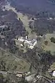
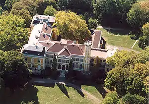 Füzérradvány, Károlyi-kastély
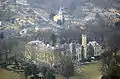

Weblinks
Commons: Füzérradvány – Sammlung von Bildern, Videos und Audiodateien
Luftaufnahme: Füzérradvány – Palast Károlyi
This article is issued from Wikipedia. The text is licensed under Creative Commons - Attribution - Sharealike. The authors of the article are listed here. Additional terms may apply for the media files, click on images to show image meta data.