Državna cesta D64
Die Državna cesta D64 (kroatisch für Nationalstraße D64) ist eine Hauptstraße in Kroatien.
| Državna cesta D64 in Kroatien | |
 | |
| Basisdaten | |
| Betreiber: | Hrvatske ceste d.o.o. |
| Gesamtlänge: | 26,9 km |
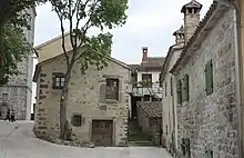 | |
| Malerischer Winkel in Gračišće | |
Verlauf
Die Straße beginnt im Westen in Pazin (italienisch: Pisino, deutsch auch: Mitterburg) an der Državna cesta D48, kreuzt die Autobahn Autocesta A8 und führt über Gračišće (italienisch: Gallignana) und Kršan (italienisch: Chersano)nach Osten, bis sie an der Državna cesta D66 rund 11 km nördlich von Labin (italienisch: Albona) endet.
Die Länge der Straße beträgt 26,9 km.[1]
Literatur
- Freytag&Berndt Superatlas Kroatien, Slowenien, o. J., ISBN 978-3-7079-0423-9
- Jugoslavija, Prometna karta, Izdanje Jugoslavenskog Leksikografiskog Zavoda u Zagrebu, o. J.
Einzelnachweise
This article is issued from Wikipedia. The text is licensed under Creative Commons - Attribution - Sharealike. The authors of the article are listed here. Additional terms may apply for the media files, click on images to show image meta data.