Colleton County
Colleton County[1] ist ein County im US-Bundesstaat South Carolina der Vereinigten Staaten. Der Verwaltungssitz (County Seat) ist Walterboro.
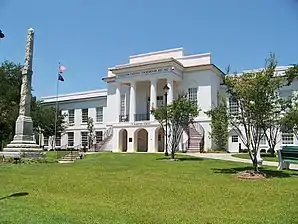 Colleton County Courthouse | |
| Verwaltung | |
|---|---|
| US-Bundesstaat: | South Carolina |
| Verwaltungssitz: | Walterboro |
| Adresse des Verwaltungssitzes: |
County Courthouse P.O. Box 157 Walterboro, SC 29488-0002 |
| Gründung: | 1798 |
| Vorwahl: | 001 843 |
| Demographie | |
| Einwohner: | 38.604 (2020) |
| Bevölkerungsdichte: | 14,11 Einwohner/km2 |
| Geographie | |
| Fläche gesamt: | 2935 km² |
| Wasserfläche: | 199 km² |
| Karte | |
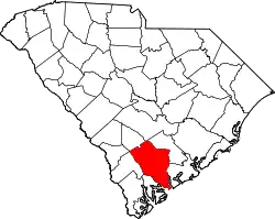 Karte von Colleton County innerhalb von South Carolina | |
| Website: www.colletoncounty.org | |
Geographie
Das County liegt im Süden von South Carolina, grenzt mit seiner Südwestspitze an den Atlantischen Ozean und hat eine Fläche von 2935 Quadratkilometern, wovon 199 Quadratkilometer Wasserfläche sind.
Das County liegt in der Atlantischen Küstenebene und wird dem South Carolina Lowcountry zugerechnet. Es wird im Westen vom Combahee und dem Salkehatchie River begrenzt, im Norden und Osten vom Edisto und dem South Fork Edisto. Im Süden fließen die drei Flüsse Combahee, Ashepoo und South Edisto (ACE Basin) in den Atlantischen Ozean, auch einige der Sea Islands gehören zum County. Nach Norden steigt das Gebiet leicht an. Das County ist überwiegend sumpfig und stark bewaldet.[2]
Es grenzt im Uhrzeigersinn an folgende Countys: Orangeburg County, Dorchester County, Charleston County, Beaufort County, Hampton County, Allendale County (über Eck) und Bamberg County.
Geschichte
| Bevölkerungsentwicklung | |||
|---|---|---|---|
| Census | Einwohner | ± in % | |
| 1790 | 20.338 | — | |
| 1800 | 24.003 | 18 % | |
| 1810 | 26.350 | 9,8 % | |
| 1820 | 26.404 | 0,2 % | |
| 1830 | 27.256 | 3,2 % | |
| 1840 | 25.548 | −6,3 % | |
| 1850 | 28.466 | 11,4 % | |
| 1860 | 41.976 | 47,5 % | |
| 1870 | 25.410 | −39,5 % | |
| 1880 | 36.386 | 43,2 % | |
| 1890 | 40.293 | 10,7 % | |
| 1900 | 33.452 | −17 % | |
| 1910 | 35.390 | 5,8 % | |
| 1920 | 29.897 | −15,5 % | |
| 1930 | 25.821 | −13,6 % | |
| 1940 | 26.268 | 1,7 % | |
| 1950 | 28.242 | 7,5 % | |
| 1960 | 27.816 | −1,5 % | |
| 1970 | 27.622 | −0,7 % | |
| 1980 | 31.776 | 15 % | |
| 1990 | 34.377 | 8,2 % | |
| 2000 | 38.264 | 11,3 % | |
| 2010 | 38.892 | 1,6 % | |
| 2020 | 38.604 | −0,7 % | |
| Zahlen nach Volkszählung | |||
Gebietsgrenzen
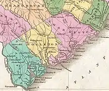
Colleton County wurde 1682 gebildet als einer der ersten drei Bezirke der englischen Provinz Carolina gegründet, später aber in drei Kirchspiele (Parish) geteilt, die die meisten Verwaltungsaufgaben übernahmen. Das County war damals auch etwas größer als heute.[3] Im Jahr 1769 wurde der Bezirk wieder aufgelöst, 1785 aber erneut geschaffen (County Seat war damals Jacksonboro) und am 1. Januar 1800 in einen Gerichtsbezirk umgewandelt. Am 16. April 1868 erhielt es wieder den Status eines eigenständigen Countys. Benannt wurde es nach John Colleton, einem Lord Proprietor der Provinz Carolina.[4] 1897 wurde das Dorchester County aus dem Bezirk Colleton herausgelöst.
Siedlungs- und Wirtschaftsgeschichte
1720 war lebten im Bezirk Colleton etwa 1.200 freie und 1.800 versklavte Menschen. Sie siedelten vor allem an den schiffbaren Küsten und Flüssen zwischen den amerikanischen Ureinwohnern, denen das Land abgekauft oder abgenommen worden war. Es entwickelte sich eine ausgeprägte Plantagenwirtschaft, im frühen 18. Jahrhundert wurden die Hauptprodukte Reis und Indigo. Die weißen Siedler kamen so zu großem Reichtum.
Nach dem Amerikanischen Unabhängigkeitskrieg löste Baumwolle Indigo als zweitwichtigstes Exportprodukt ab. 1860 waren über drei Viertel der Bevölkerung Schwarze, während die durchschnittlichen Einkommen der freien, meist weißen Bevölkerung zu den höchsten im Land gehörten.
Nach dem Sezessionskrieg und dem Ende der Sklaverei blieb die Landwirtschaft der wichtigste Wirtschaftszweig, allerdings wurde auch die Holzwirtschaft bedeutender. Während die ehemaligen Sklavenhalter nicht an ihren alten Reichtum anknüpfen konnten, lebten auch die meisten Afroamerikaner weiterhin in großer Armut. Sie erhielten meist nur eine schlechte Schulbildung. In der Great Depression stieg die Arbeitslosigkeit massiv an, viele Menschen konnten nur mit staatlicher Unterstützung überleben und emigrierten.[3]
Bauwerke
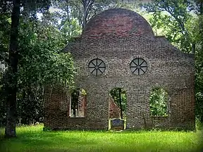

Zehn Bauwerke und Stätten des Countys sind im National Register of Historic Places (NRHP) eingetragen (Stand 27. Juli 2018).[5]
Orte im Colleton County
Im Colleton County liegen sechs Gemeinden, davon eine City und fünf Towns. Zu Statistikzwecken führt das U.S. Census Bureau zwei Census-designated places (CDP), die dem County unterstellt sind und keine Selbstverwaltung besitzen. Diese sind wie die Unincorporated Communities gemeindefreies Gebiet.
City
Towns
- Cottageville
- Edisto Beach
- Lodge
- Smoaks
- Williams
weitere Orte
- Ashepoo⊙[6]
- Ashepoo Crossing⊙[7]
- Ashepoo Siding⊙[8]
- Ashton⊙[9]
- Beck Landing⊙[10]
- Bells Crossroads (ehemals Bells)⊙[11]
- Bennetts Point (früher Benny Point oder Mosquito Wharf)⊙[12]
- Blake⊙[13]
- Bluehouse Corners (früher Blue House)⊙[14]
- Burnt Church Crossroads⊙[15]
- Burr Hill⊙[16]
- Caldwell⊙[17]
- Canadys⊙[18]
- Catholic Hill⊙[19]
- Colleton⊙[20]
- Davis Hill⊙[21]
- Drawdy (früher Drawd)⊙[22]
- Drigger Crossroads⊙[23]
- Fenwick⊙[24]
- Gloverville⊙[25]
- Goodhope Landing⊙[26]
- Green Pond⊙[27]
- Hendersonville⊙[28]
- Hickory Hill⊙[29]
- Hiotts⊙[30]
- Holly Ridge⊙[31]
- Hudsons Mill⊙[32]
- Iron Crossroads (früher Irons oder Ions Crossroads)⊙[33]
- Islandton ⊙[34] (CDP)
- Jacksonboro ⊙[35] (CDP)
- Johnsville⊙[36]
- Jonesville⊙[37]
- Kelsey Cove Landing⊙[38]
- Long Creek Landing⊙[39]
- Lowndes Landing⊙[40]
- Mas Old Field Landing⊙[41]
- Moselle⊙[42]
- Neyles⊙[43]
- Padgett Landing⊙[44]
- Padgetts⊙[45]
- Parkers Ferry Landing⊙[46]
- Pine Hill Landing⊙[47]
- Prices Landing⊙[48]
- Pringle Bend (ehemals Mashawville)⊙[49]
- Red Oak Corner⊙[50]
- Rhodes Crossroads⊙[51]
- Ritter (ehemals Fish Pond)⊙[52]
- Round O⊙[53]
- Ruffin⊙[54]
- Salkehatchie⊙[55]
- Seabrook⊙[56]
- Sidney⊙[57]
- Smyly⊙[58]
- Sniders Crossroads⊙[59]
- Springtown⊙[60]
- Stokes⊙[61]
- Thayer⊙[62]
- Tobys Bluff⊙[63]
- Weeks⊙[64]
- White Hall⊙[65]
- Wiggins⊙[66]
Wirtschaft und Infrastruktur
Heute ist im Colleton County vor allem die Holz- und Textilindustrie von Bedeutung. Auch die Landwirtschaft ist weiter wichtig, neben Schlachtvieh wird vor allem Mais und Soja produziert.[2]
Die Interstate 95 durchquert das County in Nord-Süd-Richtung, östlich von Walterboro. Ebenso verlaufen die Highways 601, 21, 17 Alt und 17 durch das County. Der U.S. Highway 15 hat einen Endpunkt in Walterboro und verläuft von dort aus nach Norden. Der Lowcountry Regional Airport ist ein Regionalflughafen bei Walterboro, der im Besitz der der Gemeinde und des Countys ist.
Filme
Im County war unter anderem das Haus und damit ein Hauptfilmort des Filmes Forrest Gump.
Siehe auch
Einzelnachweise
- Colleton County im Geographic Names Information System des United States Geological Survey. Abgerufen am 22. Februar 2011
- Colleton | county, South Carolina, United States. In: Britannica. Abgerufen am 22. Januar 2021 (englisch).
- Laylon Wayne Jordan: Colleton County. In: South Carolina Encyclopedia. University of South Carolina, Institute for Southern Studies, 10. August 2016, abgerufen am 22. Januar 2021 (amerikanisches Englisch).
- Charles Curry Aiken, Joseph Nathan Kane: The American Counties: Origins of County Names, Dates of Creation, Area, and Population Data, 1950–2010. 6. Auflage. Scarecrow Press, Lanham 2013, ISBN 978-0-8108-8762-6, S. 66.
- Suchmaske Datenbank im National Register Information System. National Park Service, abgerufen am 27. Juli 2018.
- Ashepoo im Geographic Names Information System des United States Geological Survey
- Ashepoo Crossing im Geographic Names Information System des United States Geological Survey
- Ashepoo Siding im Geographic Names Information System des United States Geological Survey
- Ashton im Geographic Names Information System des United States Geological Survey
- Beck Landing im Geographic Names Information System des United States Geological Survey
- Bells Crossroads im Geographic Names Information System des United States Geological Survey
- Bennetts Point im Geographic Names Information System des United States Geological Survey
- Blake im Geographic Names Information System des United States Geological Survey
- Bluehouse Corners im Geographic Names Information System des United States Geological Survey
- Burnt Church Crossroads im Geographic Names Information System des United States Geological Survey
- Burr Hill im Geographic Names Information System des United States Geological Survey
- Caldwell im Geographic Names Information System des United States Geological Survey
- Canadys im Geographic Names Information System des United States Geological Survey
- Catholic Hill im Geographic Names Information System des United States Geological Survey
- Colleton im Geographic Names Information System des United States Geological Survey
- Davis Hill im Geographic Names Information System des United States Geological Survey
- Drawdy im Geographic Names Information System des United States Geological Survey
- Drigger Crossroads im Geographic Names Information System des United States Geological Survey
- Fenwick im Geographic Names Information System des United States Geological Survey
- Gloverville im Geographic Names Information System des United States Geological Survey
- Goodhope Landing im Geographic Names Information System des United States Geological Survey
- Green Pond im Geographic Names Information System des United States Geological Survey
- Hendersonville im Geographic Names Information System des United States Geological Survey
- Hickory Hill im Geographic Names Information System des United States Geological Survey
- Hiotts im Geographic Names Information System des United States Geological Survey
- Holly Ridge im Geographic Names Information System des United States Geological Survey
- Hudsons Mill im Geographic Names Information System des United States Geological Survey
- Iron Crossroads im Geographic Names Information System des United States Geological Survey
- Islandton im Geographic Names Information System des United States Geological Survey
- Jacksonboro im Geographic Names Information System des United States Geological Survey
- Johnsville im Geographic Names Information System des United States Geological Survey
- Jonesville im Geographic Names Information System des United States Geological Survey
- Kelsey Cove Landing im Geographic Names Information System des United States Geological Survey
- Long Creek Landing im Geographic Names Information System des United States Geological Survey
- Lowndes Landing im Geographic Names Information System des United States Geological Survey
- Mas Old Field Landing im Geographic Names Information System des United States Geological Survey
- Moselle im Geographic Names Information System des United States Geological Survey
- Neyles im Geographic Names Information System des United States Geological Survey
- Padgett Landing im Geographic Names Information System des United States Geological Survey
- Padgetts im Geographic Names Information System des United States Geological Survey
- Parkers Ferry Landing im Geographic Names Information System des United States Geological Survey
- Pine Hill Landing im Geographic Names Information System des United States Geological Survey
- Prices Landing im Geographic Names Information System des United States Geological Survey
- Pringle Bend im Geographic Names Information System des United States Geological Survey
- Red Oak Corner im Geographic Names Information System des United States Geological Survey
- Rhodes Crossroads im Geographic Names Information System des United States Geological Survey
- Ritter im Geographic Names Information System des United States Geological Survey
- Round O im Geographic Names Information System des United States Geological Survey
- Ruffin im Geographic Names Information System des United States Geological Survey
- Salkehatchie im Geographic Names Information System des United States Geological Survey
- Seabrook im Geographic Names Information System des United States Geological Survey
- Sidney im Geographic Names Information System des United States Geological Survey
- Smyly im Geographic Names Information System des United States Geological Survey
- Sniders Crossroads im Geographic Names Information System des United States Geological Survey
- Springtown im Geographic Names Information System des United States Geological Survey
- Stokes im Geographic Names Information System des United States Geological Survey
- Thayer im Geographic Names Information System des United States Geological Survey
- Tobys Bluff im Geographic Names Information System des United States Geological Survey
- Weeks im Geographic Names Information System des United States Geological Survey
- White Hall im Geographic Names Information System des United States Geological Survey
- Wiggins im Geographic Names Information System des United States Geological Survey
Weblinks
Liste der Countys in South Carolina
Abbeville |
Aiken |
Allendale |
Anderson |
Bamberg |
Barnwell |
Beaufort |
Berkeley |
Calhoun |
Charleston |
Cherokee |
Chester |
Chesterfield |
Clarendon |
Colleton |
Darlington |
Dillon |
Dorchester |
Edgefield |
Fairfield |
Florence |
Georgetown |
Greenville |
Greenwood |
Hampton |
Horry |
Jasper |
Kershaw |
Lancaster |
Laurens |
Lee |
Lexington |
Marion |
Marlboro |
McCormick |
Newberry |
Oconee |
Orangeburg |
Pickens |
Richland |
Saluda |
Spartanburg |
Sumter |
Union |
Williamsburg |
York