Bourke-Inseln
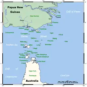
Die Bourke-Inseln sind eine unbewohnte australische Inselgruppe im Archipel der Torres-Strait-Inseln. Sie liegen etwa 95 km südöstlich der Südküste von Papua-Neuguinea und 130 km nordöstlich der Nordspitze Australiens. Es handelt sich durchweg um Koralleninseln.
| Bourke-Inseln | ||
|---|---|---|
.png.webp) Landsat-Bild der Inselgruppe | ||
| Gewässer | Pazifischer Ozean | |
| Archipel | Torres-Strait-Inseln | |
| Geographische Lage | 9° 54′ S, 143° 24′ O | |
| ||
| Anzahl der Inseln | 7 | |
| Hauptinsel | Bourke Island | |
| Gesamte Landfläche | 1,60 km² | |
| Einwohner | unbewohnt | |
 Lage der Torres-Strait-Inseln | ||
Die Inselgruppe erstreckt sich über 44 km von West (Roberts Island) zur Hauptinsel nach Ost (Bourke Island). Die Nord-Süd-Ausdehnung ist mit 17 km von Kabikane Island bis Mimi Island geringer.
Geschichte
Die Inselgruppe wurde 1836 von Charles Lewis, dem Kommandeur des Schiffs Isabella, nach Sir Richard Bourke (Gouverneur der australischen Kolonie New South Wales zwischen 1831 und 1837) benannt.
Inseln
Zur Gruppe zählt man folgende unbewohnte Inseln:
![]() Karte mit allen Koordinaten: OSM | WikiMap
Karte mit allen Koordinaten: OSM | WikiMap
| Inselname | Fläche km² |
Geokoordinate |
|---|---|---|
| Aukane Island | 0,20 | 09° 52′ 07″ S, 143° 23′ 38″ O |
| Aureed Island | 0,60 | 9° 57′ 7″ S, 143° 17′ 22″ O |
| Bourke Island | 0,12 | 9° 53′ 16″ S, 143° 29′ 16″ O |
| Kabikane Island | 0,09 | 9° 49′ 15″ S, 143° 24′ 31″ O |
| Layoak Island | 0,09 | 9° 51′ 47″ S, 143° 18′ 30″ O |
| Mimi Island | 0,11 | 9° 57′ 14″ S, 143° 23′ 48″ O |
| Roberts Island | 0,39 | 9° 59′ 11″ S, 143° 7′ 12″ O |
Verwaltungstechnisch zählt die Inselgruppe zu den Central Islands, einer Inselregion im Verwaltungsbezirk Torres Shire von Queensland.