Booby Island (Queensland)
Booby Island ist eine kleine Insel in der Torres-Straße und gehört administrativ zu Queensland, Australien. Die Insel befindet sich 23 Kilometer westlich der Prince-of-Wales-Insel sowie 45 Kilometer nordwestlich der Kap-York-Halbinsel am westlichen Eingang der Torresstraße. Da die Passage dieses Gewässers äußerst schwierig ist, sanken hier im 19. Jahrhundert zahlreiche Schiffe. 1896 wurde schließlich ein 18 Meter hoher Leuchtturm errichtet.
| Booby Island (Queensland) | ||
|---|---|---|
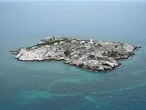 Schrägluftbild | ||
| Gewässer | Torres-Straße | |
| Geographische Lage | 10° 36′ 14″ S, 141° 54′ 40″ O | |
| ||
| Länge | 360 m | |
| Breite | 340 m | |
| Fläche | 6 ha | |
| Höchste Erhebung | 37 m | |
| Einwohner | unbewohnt | |
.png.webp) Landsat-Bild von Booby Island | ||
Den Namen hat Booby Island von den Tölpelvögeln (englisch Booby).
Historische Ansicht
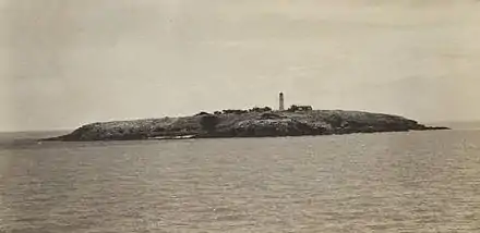
Booby Island im Mai 1912
Weblinks
- Russ Rowlett: Lighthouses of Australia: Queensland’s East Coast (Englisch) In: The Lighthouse Directory. University of North Carolina at Chapel Hill. Abgerufen am 17. September 2011.
Commons: Booby Island – Sammlung von Bildern, Videos und Audiodateien
This article is issued from Wikipedia. The text is licensed under Creative Commons - Attribution - Sharealike. The authors of the article are listed here. Additional terms may apply for the media files, click on images to show image meta data.