Bristow Island
Bristow Island ist eine unbewohnte Insel nahe der Südküste von Papua-Neuguinea in Höhe der Mündung des Fly River. Sie gehört zu den nördlichsten Torres-Strait-Inseln.
| Bristow Island (Bobo) | ||
|---|---|---|
.png.webp) Landsat-Bild von Bristow Island | ||
| Gewässer | Pazifischer Ozean | |
| Inselgruppe | Torres-Strait-Inseln | |
| Geographische Lage | 9° 7′ 24″ S, 143° 14′ 27″ O | |
| ||
| Länge | 8,1 km | |
| Breite | 5,1 km | |
| Fläche | 33,18 km² | |
| Höchste Erhebung | 20 m | |
| Einwohner | unbewohnt | |
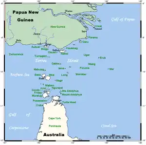 Karte der Torres-Strait-Inseln | ||
Die Insel liegt etwa 1,5 km südlich von Daru Island, auf der sich Daru, die Provinzhauptstadt der Westprovinz, befindet. Die Bewohner von Daru nennen Bristow Island Bobo.
Bristow Island ist flach und dicht mit Mangroven bewachsen.
Siehe auch
This article is issued from Wikipedia. The text is licensed under Creative Commons - Attribution - Sharealike. The authors of the article are listed here. Additional terms may apply for the media files, click on images to show image meta data.