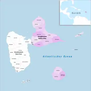
Arrondissement Pointe-à-Pitre
Das Arrondissement Pointe-à-Pitre ist eine Verwaltungseinheit des französischen Départements Guadeloupe. Hauptort (Sitz der Unterpräfektur) ist Pointe-à-Pitre.
| Arrondissement Pointe-à-Pitre | |
|---|---|
| Region | Guadeloupe |
| Département | Guadeloupe |
| Unterpräfektur | Pointe-à-Pitre |
| Einwohner | 199.474 (1. Jan. 2019) |
| Bevölkerungsdichte | 257 Einw./km² |
| Fläche | 776,39 km² |
| Gemeinden | 14 |
| INSEE-Code | 9712 |
 Lage des Arrondissements Pointe-à-Pitre im Département Guadeloupe | |
Es bestand bis zur Neuordnung der französischen Kantone im Jahr 2015 aus 23 Kantonen und 14 Gemeinden. Seit 2015 sind elf Kantone auf die Gemeinden verteilt.
Gemeinden
| Gemeinde | Einwohner 1. Januar 2019 |
Fläche km² |
Dichte Einw./km² |
Code INSEE |
Postleitzahl |
|---|---|---|---|---|---|
| Anse-Bertrand | 4.001 | 64,09 | 62 | 97102 | 97121 |
| Capesterre-de-Marie-Galante | 3.298 | 46,22 | 71 | 97108 | 97140 |
| Grand-Bourg | 4.870 | 55,75 | 87 | 97112 | 97112 |
| La Désirade | 1.419 | 21,56 | 66 | 97110 | 97127 |
| Le Gosier | 26.489 | 45,49 | 582 | 97113 | 97190 |
| Le Moule | 22.149 | 83,46 | 265 | 97117 | 97160 |
| Les Abymes | 53.514 | 70,03 | 764 | 97101 | 97139, 97142 |
| Morne-à-l’Eau | 16.495 | 69,59 | 237 | 97116 | 97111 |
| Petit-Canal | 8.203 | 74,12 | 111 | 97119 | 97131 |
| Pointe-à-Pitre | 15.181 | 2,74 | 5.541 | 97120 | 97110 |
| Port-Louis | 5.618 | 44,39 | 127 | 97122 | 97117 |
| Saint-François | 11.689 | 60,88 | 192 | 97125 | 97118 |
| Saint-Louis | 2.397 | 57,52 | 42 | 97126 | 97134 |
| Sainte-Anne | 24.151 | 80,55 | 300 | 97128 | 97180 |
| Arrondissement Pointe-à-Pitre | 199.474 | 776,39 | 257 | 9712 | – |
Kantone
This article is issued from Wikipedia. The text is licensed under Creative Commons - Attribution - Sharealike. The authors of the article are listed here. Additional terms may apply for the media files, click on images to show image meta data.