Warwick Parish
Warwick Parish bezeichnet ein 5,7 km² großes Verwaltungsgebiet von Bermuda mit 9002 Einwohnern (2016).[1][2]
| Warwick Parish | |||
|---|---|---|---|
| |||
| Koordinaten | 32° 16′ 0″ N, 64° 48′ 30″ W | ||
| Basisdaten | |||
| Staat | Bermuda | ||
| Fläche | 5,7 km² | ||
| Einwohner | 9002 (2016) | ||
| Dichte | 1.579,3 Ew./km² | ||
| Sonstiges | |||
| Zeitzone: | AST (UTC−4) | ||

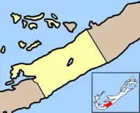
Lage des Warwick Parish innerhalb der Bermudas
Der in deutschsprachigen Staaten mit einem Landkreis vergleichbare Parish liegt im zentralen Süden der bermudischen Hauptinsel Grand Bermuda. Zum Verwaltungsbezirk zählen auch einige der Nordwestküste vorgelagerte Inseln im Great Sound. Warwick Parish grenzt südwestlich an den Southampton Parish und im Nordosten an den Paget Parish.
Das Verwaltungsgebiet ist nach dem englischen Admiral Robert Rich, 2. Earl of Warwick (1587–1658) benannt.
Weblinks
- Keith Archibald Forbes: Bermuda’s Warwick Parish. In: Bermuda and her Atlantic Islands. Bermuda Online (BOL) (englisch).
Einzelnachweise
- Melinda Williams (Hrsg.): 2016 Population and Housing Census Report. Government of Bermuda – Department of Statistics, Hamilton, Bermuda 2. Mai 2018, Population, S. 24, Table 3: Population by parish and municipality, 2016 and 2010 (englisch, gov.bm [PDF; 4,4 MB; abgerufen am 30. August 2019]).
- Melinda Williams (Hrsg.): 2016 Population and Housing Census Report. Government of Bermuda – Department of Statistics, Hamilton, Bermuda 2. Mai 2018, Population, S. 25, Table 4: Population density by parish and municipality, 2016 and 2010 (englisch, gov.bm [PDF; 4,4 MB; abgerufen am 30. August 2019]).
This article is issued from Wikipedia. The text is licensed under Creative Commons - Attribution - Sharealike. The authors of the article are listed here. Additional terms may apply for the media files, click on images to show image meta data.
