Pembroke Parish
Pembroke Parish bezeichnet ein 4,7 km² großes Verwaltungsgebiet von Bermuda mit 10.306 Einwohnern (2016, Fläche und Einwohner der Stadt Hamilton nicht eingerechnet).[1][2]
| Pembroke Parish | |||
|---|---|---|---|
| |||
| Koordinaten | 32° 17′ 58″ N, 64° 47′ 34″ W | ||
| Basisdaten | |||
| Staat | Bermuda | ||
| Fläche | 4,7 km² | ||
| Einwohner | 10.306 (2016) | ||
| Dichte | 2.188,1 Ew./km² | ||
| Postleitzahl | HM 01 bis HM 04 | ||
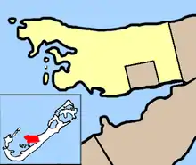
Der in deutschsprachigen Staaten mit einem Landkreis vergleichbare Parish liegt im Zentrum der bermudischen Hauptinsel Grand Bermuda und ragt westlich in den Großen Sund (Great Sound). Zum Verwaltungsbezirk zählen auch einige westlich und südlich vorgelagerte Inseln im Großen Sund. Pembroke Parish grenzt östlich an den Devonshire Parish. Hamilton, die Hauptstadt von Bermuda, liegt zwar im Gebiet, gehört aber als kreisfreie Gemeinde nicht zum Pembroke Parish.
Das Verwaltungsgebiet ist nach dem englischen Aristokraten William Herbert, 3. Earl of Pembroke (1580–1630) benannt.
Weblinks
- Keith Archibald Forbes: Bermuda’s Pembroke Parish. In: Bermuda and her Atlantic Islands. Bermuda Online (BOL) (englisch).
Einzelnachweise
- Melinda Williams (Hrsg.): 2016 Population and Housing Census Report. Government of Bermuda – Department of Statistics, Hamilton, Bermuda 2. Mai 2018, Population, S. 24, Table 3: Population by parish and municipality, 2016 and 2010 (englisch, gov.bm [PDF; 4,4 MB; abgerufen am 30. August 2019]).
- Melinda Williams (Hrsg.): 2016 Population and Housing Census Report. Government of Bermuda – Department of Statistics, Hamilton, Bermuda 2. Mai 2018, Population, S. 25, Table 4: Population density by parish and municipality, 2016 and 2010 (englisch, gov.bm [PDF; 4,4 MB; abgerufen am 30. August 2019]).
Municipality: Hamilton (Ort) | Saint George’s (Ort)
Parish: Sandys | Southampton | Warwick | Paget | Pembroke | Devonshire | Smith’s | Hamilton | Saint George’s