Sandys Parish
Sandys Parish bezeichnet ein 5,8 km² großes Verwaltungsgebiet von Bermuda mit 6983 Einwohnern (2016).[1][2]
| Sandys Parish | |||
|---|---|---|---|
| |||
| Koordinaten | 32° 18′ 0″ N, 64° 52′ 0″ W | ||
| Basisdaten | |||
| Staat | Bermuda | ||
| Fläche | 5,8 km² | ||
| Einwohner | 6983 (2016) | ||
| Dichte | 1.197,8 Ew./km² | ||
| Sonstiges | |||
| Zeitzone: | AST (UTC−4) | ||
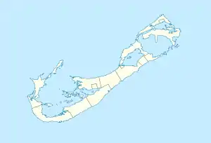
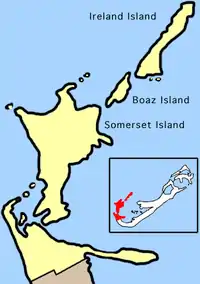
Der in deutschsprachigen Staaten mit einem Landkreis vergleichbare Parish liegt im Nordwesten der bermudischen Inselkette. Zum Verwaltungsbezirk zählen vor allem die Inseln Ireland Island North, Ireland Island South, Boaz Island und Somerset Island sowie kleine Teile im Südwesten der Hauptinsel Grand Bermuda. Sandys Parish grenzt im Süden an den Southampton Parish.
Das Verwaltungsgebiet ist nach dem englischen Aristokraten und Staatsmann Sir Edwin Sandys (1561–1629) benannt, einem Sohn des gleichnamigen Edwin Sandys, Erzbischof von York.
Weblinks
- Keith Archibald Forbes: Bermuda’s Sandys Parish. In: Bermuda and her Atlantic Islands. Bermuda Online (BOL) (englisch).
Einzelnachweise
- Melinda Williams (Hrsg.): 2016 Population and Housing Census Report. Government of Bermuda – Department of Statistics, Hamilton, Bermuda 2. Mai 2018, Population, S. 24, Table 3: Population by parish and municipality, 2016 and 2010 (englisch, gov.bm [PDF; 4,4 MB; abgerufen am 30. August 2019]).
- Melinda Williams (Hrsg.): 2016 Population and Housing Census Report. Government of Bermuda – Department of Statistics, Hamilton, Bermuda 2. Mai 2018, Population, S. 25, Table 4: Population density by parish and municipality, 2016 and 2010 (englisch, gov.bm [PDF; 4,4 MB; abgerufen am 30. August 2019]).
Municipality: Hamilton (Ort) | Saint George’s (Ort)
Parish: Sandys | Southampton | Warwick | Paget | Pembroke | Devonshire | Smith’s | Hamilton | Saint George’s