Varambon
Varambon ist eine französische Gemeinde mit 619 Einwohnern (Stand 1. Januar 2019) im Département Ain in der Region Auvergne-Rhône-Alpes; sie gehört zum Arrondissement Nantua und zum Kanton Pont-d’Ain.
| Varambon | ||
|---|---|---|
.svg.png.webp)
|
| |
| Staat | Frankreich | |
| Region | Auvergne-Rhône-Alpes | |
| Département (Nr.) | Ain (01) | |
| Arrondissement | Nantua | |
| Kanton | Pont-d’Ain | |
| Gemeindeverband | Rives de l’Ain-Pays du Cerdon | |
| Koordinaten | 46° 2′ N, 5° 19′ O | |
| Höhe | 228–347 m | |
| Fläche | 7,98 km² | |
| Einwohner | 619 (1. Januar 2019) | |
| Bevölkerungsdichte | 78 Einw./km² | |
| Postleitzahl | 01160 | |
| INSEE-Code | 01430 | |
| Website | www.varambon.com | |
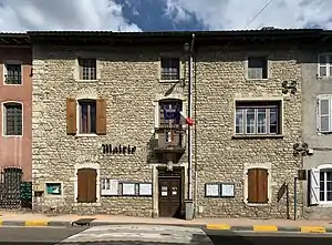 Mairie Varambon | ||

Geografie
Die Gemeinde liegt am rechten Ufer des Ain, unterhalb der Kleinstadt Pont-d’Ain am Ostrand der Dombes.
Bevölkerungsentwicklung
| Jahr | 1962 | 1968 | 1975 | 1982 | 1990 | 1999 | 2006 | 2019 |
| Einwohner | 266 | 299 | 287 | 314 | 353 | 385 | 544 | 619 |
| Quellen: Cassini und INSEE | ||||||||
Sehenswürdigkeiten
- Schloss (Monument historique, Privatbesitz)
- Kirche Sainte-Madeleine
Siehe auch: Liste der Monuments historiques in Varambon

Kirche Sainte-Madeleine
Weblinks
Commons: Varambon – Sammlung von Bildern, Videos und Audiodateien
- Offizielle Website der Gemeinde Varambon (französisch)
This article is issued from Wikipedia. The text is licensed under Creative Commons - Attribution - Sharealike. The authors of the article are listed here. Additional terms may apply for the media files, click on images to show image meta data.