Pusztahencse
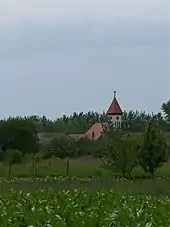
Pusztahencse ist eine ungarische Gemeinde im Kreis Paks im Komitat Tolna. Sie liegt ungefähr zehn Kilometer westlich von Paks.
| Pusztahencse | |||||
| |||||
| Basisdaten | |||||
|---|---|---|---|---|---|
| Staat: | Ungarn | ||||
| Region: | Südtransdanubien | ||||
| Komitat: | Tolna | ||||
| Kleingebiet bis 31.12.2012: | Paks | ||||
| Kreis seit 1.1.2013: | Paks | ||||
| Koordinaten: | 46° 36′ N, 18° 43′ O | ||||
| Fläche: | 31,71 km² | ||||
| Einwohner: | 984 (1. Jan. 2011) | ||||
| Bevölkerungsdichte: | 31 Einwohner je km² | ||||
| Telefonvorwahl: | (+36) 75 | ||||
| Postleitzahl: | 7038 | ||||
| KSH-kód: | 19938 | ||||
| Struktur und Verwaltung (Stand: 2015) | |||||
| Gemeindeart: | Gemeinde | ||||
| Bürgermeisterin: | Ibolya Iker (parteilos) | ||||
| Postanschrift: | Pozsonyi u. 59 7038 Pusztahencse | ||||
| Website: | |||||
| (Quelle: A Magyar Köztársaság helységnévkönyve 2011. január 1. bei Központi statisztikai hivatal) | |||||

Verkehr
Am nördlichen Rand der Gemeinde verläuft die Landstraße Nr. 6232 zwischen Paks und Nagydorog. Der nächstgelegene Bahnhof befindet sich gut fünf Kilometer nordwestlich in Nagydorog.
Weblinks
- Offizielle Website (ungarisch)
- Pusztahencse bei Magyarország helységnévtára (ungarisch)
This article is issued from Wikipedia. The text is licensed under Creative Commons - Attribution - Sharealike. The authors of the article are listed here. Additional terms may apply for the media files, click on images to show image meta data.