Provinz Ucayali
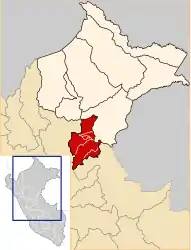
Die Provinz Ucayali liegt in der Region Loreto im Nordosten von Peru. Die Provinz hat eine Fläche von 29.293 km². Beim Zensus im Jahr 2017 lebten 54.637 Menschen in der Provinz.[1] 10 Jahre zuvor lag die Einwohnerzahl bei 61.816.[1] Verwaltungssitz ist Contamana.
| Provinz Ucayali | |
|---|---|
 Lage der Provinz in der Region Loreto | |
| Basisdaten | |
| Staat | Peru |
| Region | Loreto |
| Sitz | Contamana |
| Fläche | 29.293 km² |
| Einwohner | 54.637 (2017) |
| Dichte | 1,9 Einwohner pro km² |
| Gründung | 21. Januar 1807 |
| ISO 3166-2 | PE-LOR |
| Webauftritt | muniucayali.gob.pe (spanisch) |
| Politik | |
| Alcalde Provincial | Héctor Soto García (2019–2022) |
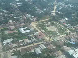 Contamana | |
Geographische Lage
Die Provinz Ucayali liegt im Süden der Region Loreto im Amazonastiefland. Der Río Ucayali durchfließt den Osten der Provinz in nördlicher Richtung. Im Westen reicht die Provinz bis zur Cordillera Azul, einem Gebirgszug der peruanischen Ostkordillere. Die Provinz Ucayali grenzt im Norden und im Osten an die Provinz Requena, im Süden an die Region Ucayali sowie im Westen an die Region San Martín.
Verwaltungsgliederung
Die Provinz Ucayali ist in sechs Distrikte unterteilt. Der Distrikt Contamana ist Sitz der Provinzverwaltung.
| Distrikt | Verwaltungssitz |
|---|---|
| Contamana | Contamana |
| Inahuaya | Inahuaya |
| Padre Márquez | Tiruntán |
| Pampa Hermosa | Pampa Hermosa |
| Sarayacu | Dos de Mayo |
| Vargas Guerra | Orellana |
Einzelnachweise
- Ucayali, Province in Loreto Region. www.citypopulation.de. Abgerufen am 30. November 2019.