Provinz Palpa
Die Provinz Palpa ist eine von fünf Provinzen der Region Ica an der Pazifikküste Perus. Die Provinz hat eine Fläche von 1232,9 km². Die Einwohnerzahl betrug im Jahr 2017 13.232.[1] Im Jahr 2007 lag diese bei 12.875.[1] Verwaltungssitz ist die Stadt Palpa.
| Provinz Palpa | |
|---|---|
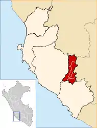 Lage der Provinz in der Region Ica | |
| Basisdaten | |
| Staat | Peru |
| Region | Ica |
| Sitz | Palpa |
| Fläche | 1.232,9 km² |
| Einwohner | 13.232 (2017) |
| Dichte | 11 Einwohner pro km² |
| Gründung | 27. Dezember 1963 |
| ISO 3166-2 | PE-ICA |
| Webauftritt | www.munipalpa.gob.pe (spanisch) |
| Politik | |
| Alcalde Provincial | José Luis Montaño Yarasca (2019–2022) |
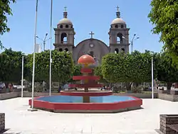 Plaza de Armas in Palpa | |
Geographische Lage
Die Provinz Palpa grenzt im Norden an die Provinz Huaytará (Huancavelica), im Osten an die Provinz Lucanas (Ayacucho), im Süden an die Provinz Nasca und im Westen an den Provinz Ica.
Verwaltungsgliederung
Die Provinz Palpa gliedert sich in fünf Distrikte (Distritos). Der Distrikt Palpa ist Sitz der Provinzverwaltung.
| Distrikt | Verwaltungssitz |
|---|---|
| Llipata | Llipata |
| Palpa | Palpa |
| Río Grande | Río Grande |
| Santa Cruz | Santa Cruz |
| Tibillo | Tibillo |
Einzelnachweise
- Peru: Ica Region – Provinces and Districts. www.citypopulation.de. Abgerufen am 6. Dezember 2019.
This article is issued from Wikipedia. The text is licensed under Creative Commons - Attribution - Sharealike. The authors of the article are listed here. Additional terms may apply for the media files, click on images to show image meta data.