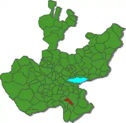
Municipio Zapotiltic
| Zapotiltic | ||
|---|---|---|
 | ||
| Symbole | ||
| ||
| Basisdaten | ||
| Staat | Mexiko | |
| Bundesstaat | Jalisco | |
| Sitz | Zapotiltic | |
| Fläche | 253 km² | |
| Einwohner | 29.192 (2010) | |
| Dichte | 115,4 Einwohner pro km² | |
| Gründung | vor 1831 | |
| Webauftritt | zapotiltic.gob.mx | |
| INEGI-Nr. | 14121 | |
| Politik | ||
| Presidente municipal | Ramiro Jr. Farias Martínez | |
Zapotiltic ist ein Municipio im mexikanischen Bundesstaat Jalisco in der Región Sur. Das Municipio hatte beim Zensus 2010 29.192 Einwohner; die Fläche des Municipios beträgt 253 km².
Größter Ort im Municipio und Verwaltungssitz ist das gleichnamige Zapotiltic. Ein zweiter Ort mit zumindest 1000 Einwohnern existiert mit El Rincón. Insgesamt umfasst das Municipio 30 Ortschaften.
In den Ausläufern der Sierra Volcánica Transversal gelegen grenzt das Municipio Zapotiltic an die Municipios Zapotlán el Grande, Tamazula de Gordiano, Tecalitlán und Tuxpan.
Das Gemeindegebiet liegt auf durchschnittlich etwa 1300 m über dem Meeresspiegel. Gut 40 % der Gemeindefläche werden landwirtschaftlich genutzt, weitere 40 % sind bewaldet.
Weblinks
Commons: Zapotiltic – Sammlung von Bildern
- Enciclopedia de los Municipios y Delegaciones de México: Municipio Zapotiltic (spanisch)
- INEGI: Datos Geográficos: Municipio Zapotiltic (spanisch; PDF)
- jalisco.gob.mx: Zapotiltic (spanisch)
This article is issued from Wikipedia. The text is licensed under Creative Commons - Attribution - Sharealike. The authors of the article are listed here. Additional terms may apply for the media files, click on images to show image meta data.

