Moratalla
Moratalla ist eine Stadt und Gemeinde in der Region Murcia (Spanien), die 83 km nordwestlich der Provinzhauptstadt Murcia liegt. Mit einer Fläche von 955 km² ist die Gemeinde nach Lorca (1676 km²) und Jumilla (972 km²) die drittgrößte der Autonomen Gemeinschaft Murcia. Moratalla zählt 7839 Einwohner (Stand 1. Januar 2019), moratalleros genannt. Bestimmende Wirtschaftszweige sind landwirtschaftliche Produkte (Oliven, Olivenöl, Mandeln, Aprikosen) und Tourismus.
| Gemeinde Moratalla | |||
|---|---|---|---|
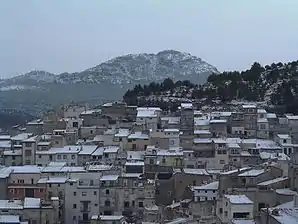 Moratalla und der Pico del Buitre | |||
| Wappen | Karte von Spanien | ||
.svg.png.webp) |
| ||
| Basisdaten | |||
| Autonome Gemeinschaft: | Murcia | ||
| Provinz: | Murcia | ||
| Comarca: | Noroeste | ||
| Koordinaten | 38° 11′ N, 1° 53′ W | ||
| Höhe: | 681 msnm | ||
| Fläche: | 954,82 km² | ||
| Einwohner: | 7.839 (1. Jan. 2019)[1] | ||
| Bevölkerungsdichte: | 8,21 Einw./km² | ||
| Postleitzahl: | 30440 | ||
| Gemeindenummer (INE): | 30028 | ||
| Verwaltung | |||
| Bürgermeister: | Juan Llorente Martínez (PSRM-PSOE) | ||
| Lage der Gemeinde | |||
 | |||

Weblinks
Einzelnachweise
- Cifras oficiales de población resultantes de la revisión del Padrón municipal a 1 de enero. Bevölkerungsstatistiken des Instituto Nacional de Estadística (Bevölkerungsfortschreibung).
Abanilla | Abarán | Águilas | Albudeite | Alcantarilla | Los Alcázares | Aledo | Alguazas | Alhama de Murcia | Archena | Beniel | Blanca | Bullas | Calasparra | Campos del Río | Caravaca de la Cruz | Cartagena | Cehegín | Ceutí | Cieza | Fortuna | Fuente Álamo de Murcia | Jumilla | Librilla | Lorca | Lorquí | Mazarrón | Molina de Segura | Moratalla | Mula | Murcia | Ojós | Pliego | Puerto Lumbreras | Ricote | San Javier | San Pedro del Pinatar | Santomera | Torre-Pacheco | Las Torres de Cotillas | Totana | Ulea | La Unión | Villanueva del Río Segura | Yecla