Liste der FFH-Gebiete im Landkreis Landshut
Die Liste der FFH-Gebiete im Landkreis Landshut zeigt die FFH-Gebiete des niederbayerischen Landkreises Landshut in Bayern. Teilweise überschneiden sie sich mit bestehenden Natur-, Landschaftsschutz- und EU-Vogelschutzgebieten. Im Landkreis befinden sich acht und zum Teil mit anderen Landkreisen überlappende FFH-Gebiete.
| Name | Bild | Kennung | Kreis | Einzelheiten | Position | Fläche Hektar |
Datum | ||
|---|---|---|---|---|---|---|---|---|---|
| Bucher Graben | .jpg.webp) |
7438-371 WDPA: 555521933 |
Landkreis Landshut | ⊙ | 46,35 | ||||
| Gelbbauchunken-Habitate um Niedererlbach | 7538-371 WDPA: 555521967 |
Landkreis Landshut | ⊙ | 24,84 | |||||
| Isarauen von Unterföhring bis Landshut |
 |
7537-301 WDPA: 555521966 |
Landkreis Erding, Landkreis Freising, Landkreis München | auch in München, Landkreis Landshut, Landshut | ⊙ | 5.276,00 | |||
| Kleine Vils |
 |
7539-371 WDPA: 555521968 |
Landkreis Landshut | ⊙ | 28,29 | ||||
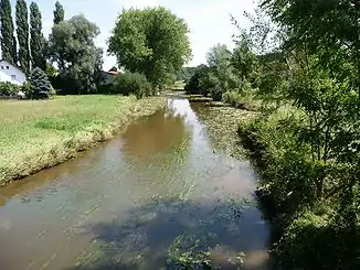
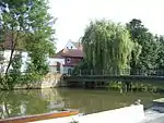
| Klötzlmühlbach | 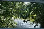 |
7438-372 WDPA: 555521934 |
Landshut, Landkreis Landshut | ⊙ | 54,06 | ||||
| Leiten der Unteren Isar |
 |
7439-371 WDPA: 555521935 |
Landshut, Landkreis Dingolfing-Landau, Landkreis Landshut | ⊙ | 642,58 | ||||
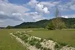
| Mettenbacher, Grießenbacher und Königsauer Moos (Unteres Isartal) |
 |
7341-371 WDPA: 555521905 |
Landkreis Dingolfing-Landau, Landkreis Landshut | ⊙ | 220,46 | ||||
| Vilstal zwischen Vilsbiburg und Marklkofen |
 |
7440-371 WDPA: 555521936 |
Landkreis Dingolfing-Landau, Landkreis Landshut | ⊙ | 834,65 | ||||
| Legende für Fauna-Flora-Habitat | |||||||||
Siehe auch
Weblinks
FFH-Gebiete in den Landkreisen
Aichach-Friedberg |
Altötting |
Amberg-Sulzbach |
Ansbach |
Aschaffenburg |
Augsburg |
Bad Kissingen |
Bad Tölz-Wolfratshausen |
Bamberg |
Bayreuth |
Berchtesgadener Land |
Cham |
Coburg |
Dachau |
Deggendorf |
Dillingen an der Donau |
Dingolfing-Landau |
Donau-Ries |
Ebersberg |
Eichstätt |
Erding |
Erlangen-Höchstadt |
Forchheim |
Freising |
Freyung-Grafenau |
Fürstenfeldbruck |
Fürth |
Garmisch-Partenkirchen |
Günzburg |
Haßberge |
Hof |
Kelheim |
Kitzingen |
Kronach |
Kulmbach |
Landsberg am Lech |
Landshut |
Lichtenfels |
Lindau (Bodensee) |
Main-Spessart |
Miesbach |
Miltenberg |
Mühldorf am Inn |
München |
Neuburg-Schrobenhausen |
Neumarkt in der Oberpfalz |
Neustadt an der Aisch-Bad Windsheim |
Neustadt an der Waldnaab |
Neu-Ulm |
Nürnberger Land |
Oberallgäu |
Ostallgäu |
Passau |
Pfaffenhofen an der Ilm |
Regen |
Regensburg |
Rhön-Grabfeld |
Rosenheim |
Roth |
Rottal-Inn |
Schwandorf |
Schweinfurt |
Starnberg |
Straubing-Bogen |
Tirschenreuth |
Traunstein |
Unterallgäu |
Weilheim-Schongau |
Weißenburg-Gunzenhausen |
Wunsiedel im Fichtelgebirge |
Würzburg
FFH-Gebiete in den kreisfreien Städten
Amberg |
Ansbach |
Aschaffenburg |
Augsburg |
Bamberg |
Bayreuth |
Coburg |
Fürth |
Ingolstadt |
Kaufbeuren |
Landshut |
Memmingen |
München |
Nürnberg |
Passau |
Regensburg |
Rosenheim |
Schwabach |
Schweinfurt |
Straubing |
Würzburg