Liste der Einträge im National Register of Historic Places im Stephenson County
Die Liste der Einträge im National Register of Historic Places im Stephenson County in Illinois führt alle Bauwerke und historischen Stätten im Stephenson County auf, die in das National Register of Historic Places aufgenommen wurden.[1]

Aktuelle Einträge
| Lfd. Nr. | Name im NRHP | Bild | Jahr der Eintragung | Adresse / Lage | Ort | NRHP-ID |
|---|---|---|---|---|---|---|
| 1 | John H. Addams Homestead | 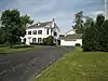 |
1979 | 425 North Mill Street 42° 23′ 26″ N, 89° 38′ 16″ W |
Cedarville | 79000871 |
| 2 | AF and AM Lodge 687 | 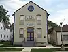 |
2003 | 203 West High Street 42° 28′ 6″ N, 89° 38′ 44″ W |
Orangeville | 03000354 |
| 3 | James Bruce Round Barn | 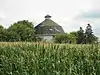 |
1984 | South Park Road Ecke West Becker School Road 42° 15′ 7″ N, 89° 38′ 57″ W |
Freeport | 84001157 |
| 4 | Central House | 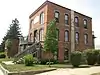 |
1999 | 210 West High Street 42° 28′ 9″ N, 89° 38′ 47″ W |
Orangeville | 99000585 |
| 5 | Charles Fehr Round Barn | 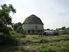 |
1984 | North Zimmermann Road, nordöstlich von Orangeville 42° 29′ 46″ N, 89° 31′ 20″ W |
Orangeville | 84001152 |
| 6 | Gerald Harbach Round Barn | 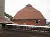 |
1984 | U.S. Highway 20 östlich von Eleroy 42° 19′ 40″ N, 89° 44′ 4″ W |
Eleroy | 84001155 |
| 7 | Chris Jensen Round Barn | 1984 | 11723 West Galena Road 42° 23′ 30″ N, 89° 50′ 6″ W |
Lena | 84001150 | |
| 8 | Kellogg's Grove | 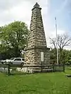 |
1978 | Südöstlich von Kent 42° 17′ 46″ N, 89° 53′ 13″ W |
Kent | 78001191 |
| 9 | Lena Water Tower | 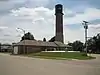 |
1997 | 201 Vernon Street 42° 22′ 49″ N, 89° 49′ 41″ W |
Lena | 97000034 |
| 10 | Dennis Otte Round Barn | 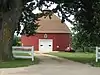 |
1984 | North Flensburg Road, östlich von Eleroy 42° 20′ 1″ N, 89° 44′ 16″ W |
Eleroy | 84001164 |
| 11 | People's State Bank | 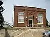 |
2004 | 300 West High Street 42° 28′ 15″ N, 89° 38′ 49″ W |
Orangeville | 04000868 |
| 12 | William Ritzman House | 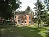 |
2000 | 10715 IL 26 N 42° 27′ 33″ N, 89° 38′ 30″ W |
Orangeville | 00000949 |
| 13 | Soldiers' Monument | 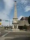 |
1998 | 15 North Galena Avenue 42° 17′ 52″ N, 89° 37′ 19″ W |
Freeport | 98000461 |
| 14 | Stephenson County Courthouse | 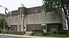 |
1974 | Courthouse Square 42° 17′ 53″ N, 89° 37′ 19″ W |
Freeport | 74002284 |
| 15 | Oscar Taylor House | 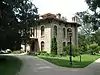 |
1984 | 1440 South Carroll Avenue 42° 17′ 4″ N, 89° 36′ 54″ W |
Freeport | 84001165 |
| 16 | Union House | 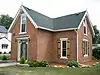 |
2000 | 207 West High Street 42° 28′ 6″ N, 89° 38′ 45″ W |
Orangeville | 00000472 |
Frühere Einträge
| Lfd. Nr. | Name im NRHP | Bild | Jahr der Eintragung | Adresse / Lage | Ort | NRHP-ID |
|---|---|---|---|---|---|---|
| 1 | Clyde Leek Round Barn | 1995 | North Dakota Road | Dakota | 84001161 |
Siehe auch
Einzelnachweise
- Auszug aus dem National Register of Historic Places - Stephenson County Abgerufen am 18. Januar 2013

National Register of Historic Places in Illinois
Adams | Alexander | Bond | Boone | Brown | Bureau | Calhoun | Carroll | Cass | Champaign | Christian | Clark | Clay | Clinton | Coles | Cook (inkl. Chicago) | Crawford | Cumberland | DeKalb | DeWitt | Douglas | DuPage | Edgar | Edwards | Effingham | Fayette | Ford | Franklin | Fulton | Gallatin | Greene | Grundy | Hamilton | Hancock | Hardin | Henderson | Henry | Iroquois | Jackson | Jasper | Jefferson | Jersey | Jo Daviess | Johnson | Kane | Kankakee | Kendall | Knox | LaSalle | Lake | Lawrence | Lee | Livingston | Logan | Macon | Macoupin | Madison | Marion | Marshall | Mason | Massac | McDonough | McHenry | McLean | Menard | Mercer | Monroe | Montgomery | Morgan | Moultrie | Ogle | Peoria | Perry | Piatt | Pike | Pope | Pulaski | Putnam | Randolph | Richland | Rock Island | Saline | Sangamon | Schuyler | Scott | Shelby | St. Clair | Stark | Stephenson | Tazewell | Union | Vermilion | Wabash | Warren | Washington | Wayne | White | Whiteside | Will | Williamson | Winnebago | Woodford