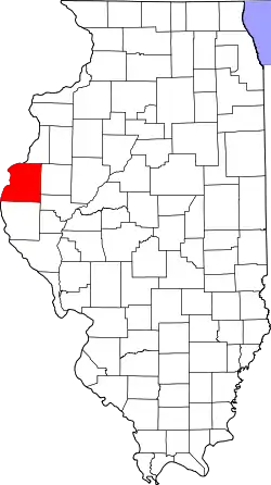
Liste der Einträge im National Register of Historic Places im Hancock County (Illinois)
Die Liste der Einträge im National Register of Historic Places im Hancock County in Illinois führt alle Bauwerke und historischen Stätten im Hancock County auf, die in das National Register of Historic Places aufgenommen wurden.[1]
Legende
| NRHP | Historic Place |
|---|---|
| HD | Historic District |
Aktuelle Einträge
| [2] | Name[3] | Bild | Eintragsdatum | Lage | Ort | Beschreibung |
|---|---|---|---|---|---|---|
| 1 | Cambre House and Farm | 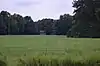 Cambre House and Farm |
1984 ID-Nr. 84000308 |
Südwestlich von Niota 40° 35′ 38″ N, 91° 20′ 35″ W |
Niota | |
| 2 | Carthage Courthouse Square Historic District |  Carthage Courthouse Square Historic District |
1986 ID-Nr. 86001482 |
Abgegrenzt durch Main Street, Adams Street, Wabash Street und Madison Street 40° 24′ 47″ N, 91° 8′ 7″ W |
Carthage | |
| 3 | Carthage Jail | 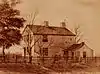 Carthage Jail |
1973 ID-Nr. 73000703 |
Walnut Street Ecke North Fayette Street 40° 24′ 56″ N, 91° 7′ 55″ W |
Carthage | |
| 4 | Cyrus Felt House | 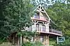 Cyrus Felt House |
1980 ID-Nr. 80001366 |
Rund 5 km nördlich von Hamilton 40° 26′ 1″ N, 91° 22′ 13″ W |
Hamilton | |
| 5 | La Harpe City Hall |  La Harpe City Hall |
1991 ID-Nr. 91001689 |
207 East Main Street 40° 35′ 0″ N, 90° 58′ 2″ W |
La Harpe | |
| 6 | La Harpe Historic District | 1987 ID-Nr. 87000031 |
100-124 West Main Street, 100-122 und 101-129 East Main Street, 101-121 South Center Street sowie City Park 40° 34′ 59″ N, 90° 58′ 10″ W |
La Harpe | ||
| 7 | Nauvoo Historic District | .jpg.webp) Nauvoo Historic District |
1966 ID-Nr. 66000321 |
Nauvoo und Umgebung 40° 33′ 5″ N, 91° 22′ 18″ W |
Nauvoo | |
| 8 | William J. Reimbold House |  William J. Reimbold House |
1987 ID-Nr. 87002033 |
950 White Street 40° 32′ 51″ N, 91° 23′ 18″ W |
Nauvoo | |
| 9 | Warsaw Historic District |  Warsaw Historic District |
1977 ID-Nr. 77000486 |
Abgegrenzt durch den Mississippi River, die Marion Street und die 11th Street 40° 21′ 48″ N, 91° 25′ 58″ W |
Warsaw |
Siehe auch
Einzelnachweise
- Auszug aus dem National Register of Historic Places - Hancock County Abgerufen am 6. Dezember 2012
- Die Nummerierung in dieser Listenspalte ist an der vom National Park Service vorgelegten Reihenfolge der Einträge orientiert; die Farben unterscheiden verschiedene Schutzgebietstypen des National Park Systems mit landesweiter Bedeutung (z. B. National Historic Landmarks) von den sonstigen Einträgen im National Register of Historic Places.
- National Register Information System. In: National Register of Historic Places. National Park Service. Abgerufen am 9. Juli 2010.

National Register of Historic Places in Illinois
Adams | Alexander | Bond | Boone | Brown | Bureau | Calhoun | Carroll | Cass | Champaign | Christian | Clark | Clay | Clinton | Coles | Cook (inkl. Chicago) | Crawford | Cumberland | DeKalb | DeWitt | Douglas | DuPage | Edgar | Edwards | Effingham | Fayette | Ford | Franklin | Fulton | Gallatin | Greene | Grundy | Hamilton | Hancock | Hardin | Henderson | Henry | Iroquois | Jackson | Jasper | Jefferson | Jersey | Jo Daviess | Johnson | Kane | Kankakee | Kendall | Knox | LaSalle | Lake | Lawrence | Lee | Livingston | Logan | Macon | Macoupin | Madison | Marion | Marshall | Mason | Massac | McDonough | McHenry | McLean | Menard | Mercer | Monroe | Montgomery | Morgan | Moultrie | Ogle | Peoria | Perry | Piatt | Pike | Pope | Pulaski | Putnam | Randolph | Richland | Rock Island | Saline | Sangamon | Schuyler | Scott | Shelby | St. Clair | Stark | Stephenson | Tazewell | Union | Vermilion | Wabash | Warren | Washington | Wayne | White | Whiteside | Will | Williamson | Winnebago | Woodford