Liste der Einträge im National Register of Historic Places im Ogle County
Die Liste der Registered Historic Places im Ogle County in Illinois führt alle 24 Bauwerke und historischen Stätten im Ogle County auf, die in das National Register of Historic Places aufgenommen wurden.[1]
Legende
| NRHP | Historic Place |
|---|---|
| HD | Historic District |
| NHL | National Historic Landmark |
Aktuelle Einträge
| Lfd. Nr. | Name im NRHP | Bild | Jahr der Eintragung | Adresse / Lage | Ort | NRHP-ID |
|---|---|---|---|---|---|---|
| 1 | Henry D. Barber House |  |
1974 | 410 West Mason Street 41° 59′ 5″ N, 89° 35′ 41″ W |
Polo | 74000770 |
| 2 | Bryant H. and Lucie Barber House |  |
1993 | 103 North Barber Avenue 41° 59′ 11″ N, 89° 34′ 54″ W |
Polo | 92001849 |
| 3 | Buffalo Grove Lime Kiln | 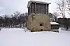 |
2002 | Galena Trail Road 41° 59′ 10″ N, 89° 36′ 37″ W |
Polo | 02001348 |
| 4 | Buffalo Township Public Library |  |
1995 | 302 West Mason Street 41° 59′ 11″ N, 89° 34′ 50″ W |
Polo | 95001236 |
| 5 | Camling-Cline Mound Group | 1979 | Oregon | 79003851 | ||
| 6 | Chana School | 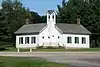 |
2005 | 201 North River Road 42° 1′ 11″ N, 89° 19′ 27″ W |
Oregon | 05001369 |
| 7 | Chicago, Burlington and Quincy Railroad Depot | 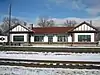 |
1997 | 400 Collins Street 42° 0′ 6″ N, 89° 19′ 55″ W |
Oregon | 97000817 |
| 8 | City and Town Hall | 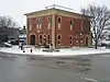 |
1992 | 4th Avenue Ecke 6th Street 41° 55′ 21″ N, 89° 4′ 2″ W |
Rochelle | 92001006 |
| 9 | John Deere House and Shop |  |
1966 | Illinois Street Ecke Clinton Street 41° 53′ 46″ N, 89° 24′ 57″ W |
Grand Detour | 66000327 |
| 10 | Flagg Township Public Library | 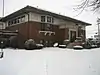 |
1973 | 7th Street Ecke 4th Avenue 41° 55′ 24″ N, 89° 4′ 5″ W |
Rochelle | 73000713 |
| 11 | Samuel M. Hitt House |  |
1985 | 7782 IL 64 W 42° 3′ 21″ N, 89° 29′ 12″ W |
Mount Morris | 85002841 |
| 12 | William H. Holcomb House | 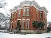 |
1973 | 526 North 7th Street 41° 55′ 23″ N, 89° 4′ 19″ W |
Rochelle | 73000714 |
| 13 | Black Hawk Statue |  |
2009 | 1411 North River Road (im Lowden Memorial State Park) 42° 2′ 2″ N, 89° 19′ 34″ W |
Oregon | 09000871 |
| 14 | John McGrath House | 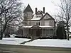 |
1996 | 403 West Mason Street 41° 59′ 10″ N, 89° 34′ 54″ W |
Polo | 96000513 |
| 15 | William Moats Farm | 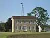 |
1987 | Wood Road 41° 54′ 5″ N, 89° 14′ 50″ W |
Nördlich von Ashton | 86003724 |
| 16 | Ogle County Courthouse | 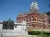 |
1981 | Courthouse Square 42° 1′ 0″ N, 89° 20′ 0″ W |
Oregon | 81000222 |
| 17 | Oregon Commercial Historic District | 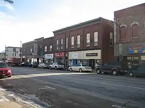 |
2006 | Abgegrenzt durch Jefferson Street, Franklin Street, 5th Street und 3rd Street 42° 0′ 53″ N, 89° 19′ 56″ W |
Oregon | 06000713 |
| 18 | Oregon Public Library | 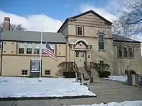 |
2003 | 300 Jefferson Street 42° 0′ 48″ N, 89° 19′ 48″ W |
Oregon | 03000352 |
| 19 | Pinehill Inn | 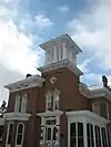 |
1978 | 400 Mix Street 42° 1′ 5″ N, 89° 20′ 26″ W |
Oregon | 78001179 |
| 20 | Polo Independent Order of Odd Fellows Lodge No. 197 |  |
2004 | 117 West Mason Street 41° 59′ 17″ N, 89° 34′ 45″ W |
Polo | 04001302 |
| 21 | Soldier's Monument | 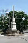 |
1985 | Chestnut Street Ecke 2nd Street 42° 8′ 0″ N, 89° 16′ 0″ W |
Byron | 85000268 |
| 22 | Stillman's Run Battle Site | 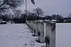 |
1983 | Roosevelt Street Ecke Spruce Street 42° 6′ 24″ N, 89° 10′ 34″ W |
Stillman Valley | 83003587 |
| 23 | Village of Davis Junction Town Hall | 2008 | 202 Pacific Avenue 42° 6′ 1″ N, 89° 5′ 52″ W |
Davis Junction | 08000504 | |
| 24 | White Pines State Park Lodge and Cabins |  |
1985 | South Forest Road 41° 59′ 40″ N, 89° 27′ 53″ W |
Mount Morris | 85002404 |
Siehe auch
Einzelnachweise
- Auszug aus dem National Register of Historic Places - Grant County Abgerufen am 15. Juli 2012

National Register of Historic Places in Illinois
Adams | Alexander | Bond | Boone | Brown | Bureau | Calhoun | Carroll | Cass | Champaign | Christian | Clark | Clay | Clinton | Coles | Cook (inkl. Chicago) | Crawford | Cumberland | DeKalb | DeWitt | Douglas | DuPage | Edgar | Edwards | Effingham | Fayette | Ford | Franklin | Fulton | Gallatin | Greene | Grundy | Hamilton | Hancock | Hardin | Henderson | Henry | Iroquois | Jackson | Jasper | Jefferson | Jersey | Jo Daviess | Johnson | Kane | Kankakee | Kendall | Knox | LaSalle | Lake | Lawrence | Lee | Livingston | Logan | Macon | Macoupin | Madison | Marion | Marshall | Mason | Massac | McDonough | McHenry | McLean | Menard | Mercer | Monroe | Montgomery | Morgan | Moultrie | Ogle | Peoria | Perry | Piatt | Pike | Pope | Pulaski | Putnam | Randolph | Richland | Rock Island | Saline | Sangamon | Schuyler | Scott | Shelby | St. Clair | Stark | Stephenson | Tazewell | Union | Vermilion | Wabash | Warren | Washington | Wayne | White | Whiteside | Will | Williamson | Winnebago | Woodford