Liste der Einträge im National Register of Historic Places im Jackson County (Illinois)
Die Liste der Einträge im National Register of Historic Places im Jackson County in Illinois führt die Bauwerke und historischen Stätten im Jackson County auf, die in das National Register of Historic Places aufgenommen wurden.[1]
Legende
| NRHP | Historic Place |
|---|---|
| HD | Historic District |
Aktuelle Einträge
| [2] | Name[3] | Bild | Eintragsdatum | Lage | Ort | Beschreibung |
|---|---|---|---|---|---|---|
| 1 | Cleiman Mound and Village Site | 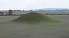 Cleiman Mound and Village Site |
1977 ID-Nr. 77000487 |
Adresse nicht veröffentlicht |
Gorham | |
| 2 | R. Buckminster & Anne Hewlett Fuller Dome Home | 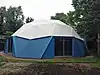 R. Buckminster & Anne Hewlett Fuller Dome Home |
2006 ID-Nr. 06000012 |
407 South Forest Avenue 37° 43′ 30″ N, 89° 13′ 31″ W |
Carbondale | |
| 3 | Giant City State Park Lodge and Cabins | 1985 ID-Nr. 85002403 |
RR #1 37° 35′ 31″ N, 89° 10′ 59″ W |
Makanda | ||
| 4 | Giant City Stone Fort Site | 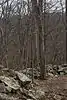 Giant City Stone Fort Site |
2002 ID-Nr. 02000848 |
Stone Fort Road 37° 37′ 24″ N, 89° 11′ 49″ W |
Makanda | |
| 5 | Grand Tower Mining, Manufacturing and Transportation Company Site |  Grand Tower Mining, Manufacturing and Transportation Company Site |
1979 ID-Nr. 79000839 |
Devil’s Backbone Park 37° 38′ 9″ N, 89° 30′ 31″ W |
Grand Tower | |
| 6 | Grange Hall | 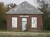 Grange Hall |
1990 ID-Nr. 90000722 |
SR 127/13 S of Beaucoup Cr. 37° 49′ 10″ N, 89° 19′ 19″ W |
Murphysboro | |
| 7 | Robert W. Hamilton House | 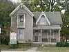 Robert W. Hamilton House |
1982 ID-Nr. 82002540 |
203 South 13th Street 37° 45′ 46″ N, 89° 20′ 13″ W |
Murphysboro | |
| 8 | Cornelius Hennessy Building | 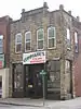 Cornelius Hennessy Building |
2000 ID-Nr. 00001331 |
1023 Chestnut Street 37° 45′ 48″ N, 89° 20′ 7″ W |
Murphysboro | |
| 9 | William H. Hull House | 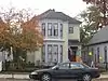 William H. Hull House |
2006 ID-Nr. 05001602 |
1517 Walnut Street 37° 45′ 51″ N, 89° 20′ 24″ W |
Murphysboro | |
| 10 | Illinois Central Railroad Passenger Depot | 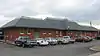 Illinois Central Railroad Passenger Depot |
2002 ID-Nr. 02000457 |
111 South Illinois Avenue 37° 43′ 43″ N, 89° 13′ 0″ W |
Carbondale | |
| 11 | Liberty Theater | 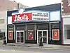 Liberty Theater |
2012 ID-Nr. 12000322 |
1333 Walnut Street 37° 45′ 50,9″ N, 89° 20′ 15,6″ W |
Murphysboro | |
| 12 | Mobile and Ohio Railroad Depot | 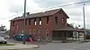 Mobile and Ohio Railroad Depot |
1984 ID-Nr. 84000317 |
1701 Walnut Street 37° 45′ 50″ N, 89° 20′ 31″ W |
Murphysboro | |
| 13 | Murphysboro Elks Lodge | 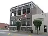 Murphysboro Elks Lodge |
2005 ID-Nr. 05001255 |
1329 Walnut Street 37° 45′ 58″ N, 89° 20′ 15″ W |
Murphysboro | |
| 14 | Reef House | 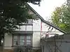 Reef House |
1985 ID-Nr. 85002839 |
411 South Poplar Street 37° 43′ 23″ N, 89° 13′ 17″ W |
Carbondale | |
| 15 | Riverside Park Bandshell | 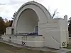 Riverside Park Bandshell |
2012 ID-Nr. 12000323 |
22nd Street und Commercial Street 37° 45′ 28,6″ N, 89° 21′ 27,4″ W |
Murphysboro | |
| 16 | West Walnut Street Historic District | 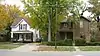 West Walnut Street Historic District |
1975 ID-Nr. 75000664 |
Abgegrenzt durch West Elm Street, South Poplar Street, West Main Street und South Forest Street 37° 43′ 31″ N, 89° 13′ 23″ W |
Carbondale | |
| 17 | Woodlawn Cemetery | 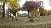 Woodlawn Cemetery |
1985 ID-Nr. 85003219 |
405 East Main Street 37° 43′ 37″ N, 89° 12′ 38″ W |
Carbondale |
Siehe auch
Einzelnachweise
- Auszug aus dem National Register of Historic Places – Jackson County Abgerufen am 4. August 2012
- Die Nummerierung in dieser Listenspalte ist an der vom National Park Service vorgelegten Reihenfolge der Einträge orientiert; die Farben unterscheiden verschiedene Schutzgebietstypen des National Park Systems mit landesweiter Bedeutung (z. B. National Historic Landmarks) von den sonstigen Einträgen im National Register of Historic Places.
- National Register Information System. In: National Register of Historic Places. National Park Service. Abgerufen am 9. Juli 2010.

National Register of Historic Places in Illinois
Adams | Alexander | Bond | Boone | Brown | Bureau | Calhoun | Carroll | Cass | Champaign | Christian | Clark | Clay | Clinton | Coles | Cook (inkl. Chicago) | Crawford | Cumberland | DeKalb | DeWitt | Douglas | DuPage | Edgar | Edwards | Effingham | Fayette | Ford | Franklin | Fulton | Gallatin | Greene | Grundy | Hamilton | Hancock | Hardin | Henderson | Henry | Iroquois | Jackson | Jasper | Jefferson | Jersey | Jo Daviess | Johnson | Kane | Kankakee | Kendall | Knox | LaSalle | Lake | Lawrence | Lee | Livingston | Logan | Macon | Macoupin | Madison | Marion | Marshall | Mason | Massac | McDonough | McHenry | McLean | Menard | Mercer | Monroe | Montgomery | Morgan | Moultrie | Ogle | Peoria | Perry | Piatt | Pike | Pope | Pulaski | Putnam | Randolph | Richland | Rock Island | Saline | Sangamon | Schuyler | Scott | Shelby | St. Clair | Stark | Stephenson | Tazewell | Union | Vermilion | Wabash | Warren | Washington | Wayne | White | Whiteside | Will | Williamson | Winnebago | Woodford