Liste der Einträge im National Register of Historic Places im Logan County (Illinois)
Die Liste der Einträge im National Register of Historic Places im Logan County in Illinois führt alle Bauwerke und historischen Stätten im Logan County auf, die in das National Register of Historic Places aufgenommen wurden.[1]
Legende
| NRHP | Historic Place |
|---|---|
| HD | Historic District |
Aktuelle Einträge
| [2] | Name[3] | Bild | Eintragsdatum | Lage | Ort | Beschreibung |
|---|---|---|---|---|---|---|
| 1 | Allen Chapel African Methodist Episcopal Church | 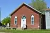 Allen Chapel African Methodist Episcopal Church |
2004 ID-Nr. 04000422 |
902 Broadway 40° 8′ 48″ N, 89° 21′ 33″ W |
Lincoln | |
| 2 | Atlanta Public Library | 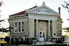 Atlanta Public Library |
1979 ID-Nr. 79000852 |
Race Street Ecke Arch Street 40° 15′ 13″ N, 89° 14′ 2″ W |
Atlanta | |
| 3 | Robert Buckles Barn | 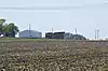 Robert Buckles Barn |
1983 ID-Nr. 83000326 |
Südöstlich von Mount Pulaski 39° 59′ 8″ N, 89° 16′ 25″ W |
Mount Pulaski | |
| 4 | Downey Building | 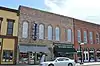 Downey Building |
2004 ID-Nr. 04000069 |
110-112 Southwest Arch Street 40° 15′ 37″ N, 89° 13′ 53″ W |
Atlanta | |
| 5 | Stephan A. Foley House | 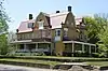 Stephan A. Foley House |
1984 ID-Nr. 84001141 |
427 Tremont Street 40° 9′ 8″ N, 89° 21′ 53″ W |
Lincoln | |
| 6 | J. H. Hawes Elevator | 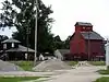 J. H. Hawes Elevator |
1991 ID-Nr. 91000571 |
2nd Street 40° 15′ 39″ N, 89° 14′ 2″ W |
Atlanta | |
| 7 | Hoblit House | 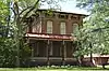 Hoblit House |
2007 ID-Nr. 07000454 |
505 North College Avenue 40° 9′ 14″ N, 89° 21′ 52″ W |
Lincoln | |
| 8 | Lincoln Courthouse Square Historic District | 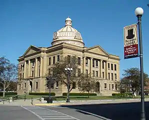 Lincoln Courthouse Square Historic District |
1985 ID-Nr. 85003166 |
Abgegrenzt durch Sangamon Street, Pekin Street, Chicago Street, Delaware Street, Broadway Street und Pulaski Street 40° 8′ 49″ N, 89° 21′ 47″ W |
Lincoln | |
| 9 | Lincoln Public Library | 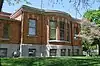 Lincoln Public Library |
1980 ID-Nr. 80001384 |
725 Pekin Street 39° 50′ 24,6″ N, 89° 23′ 44,7″ W |
Lincoln | |
| 10 | Theodore H. O. Mattfeldt House | 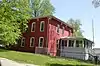 Theodore H. O. Mattfeldt House |
1996 ID-Nr. 96000853 |
202 South Marion Street 40° 0′ 30″ N, 89° 17′ 12″ W |
Mount Pulaski | |
| 11 | Mount Pulaski Courthouse | 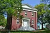 Mount Pulaski Courthouse |
1978 ID-Nr. 78001164 |
Public Square 40° 0′ 34″ N, 89° 17′ 10″ W |
Mount Pulaski | |
| 12 | University Hall |  University Hall |
1973 ID-Nr. 73000711 |
300 Keokuk Street 40° 9′ 24″ N, 89° 21′ 33″ W |
Lincoln |
Siehe auch
Einzelnachweise
- Auszug aus dem National Register of Historic Places – Logan County Abgerufen am 17. Dezember 2012
- Die Nummerierung in dieser Listenspalte ist an der vom National Park Service vorgelegten Reihenfolge der Einträge orientiert; die Farben unterscheiden verschiedene Schutzgebietstypen des National Park Systems mit landesweiter Bedeutung (z. B. National Historic Landmarks) von den sonstigen Einträgen im National Register of Historic Places.
- National Register Information System. In: National Register of Historic Places. National Park Service. Abgerufen am 9. Juli 2010.

National Register of Historic Places in Illinois
Adams | Alexander | Bond | Boone | Brown | Bureau | Calhoun | Carroll | Cass | Champaign | Christian | Clark | Clay | Clinton | Coles | Cook (inkl. Chicago) | Crawford | Cumberland | DeKalb | DeWitt | Douglas | DuPage | Edgar | Edwards | Effingham | Fayette | Ford | Franklin | Fulton | Gallatin | Greene | Grundy | Hamilton | Hancock | Hardin | Henderson | Henry | Iroquois | Jackson | Jasper | Jefferson | Jersey | Jo Daviess | Johnson | Kane | Kankakee | Kendall | Knox | LaSalle | Lake | Lawrence | Lee | Livingston | Logan | Macon | Macoupin | Madison | Marion | Marshall | Mason | Massac | McDonough | McHenry | McLean | Menard | Mercer | Monroe | Montgomery | Morgan | Moultrie | Ogle | Peoria | Perry | Piatt | Pike | Pope | Pulaski | Putnam | Randolph | Richland | Rock Island | Saline | Sangamon | Schuyler | Scott | Shelby | St. Clair | Stark | Stephenson | Tazewell | Union | Vermilion | Wabash | Warren | Washington | Wayne | White | Whiteside | Will | Williamson | Winnebago | Woodford